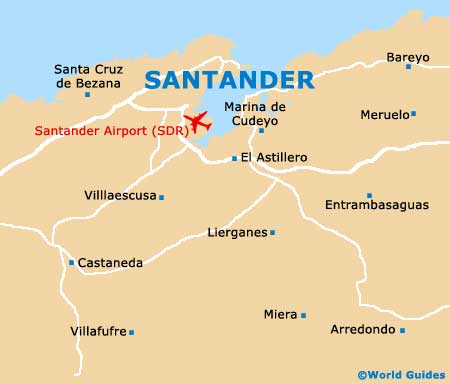
Santander Maps and Orientation
(Santander, Cantabria, Spain)
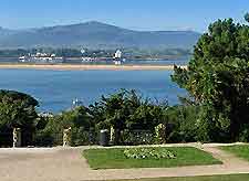
The Spanish port city of Santander is located within the Cantabria province and on the northern coastline of Spain, next to the Basque Country. Almost 200,000 people now live in Santander and this number greatly swells during the summer months, when tourists arrive to soak up the sunshine on the city's Sardinero Beach (Playa del Sardinero).
The city itself stands on the northerly side of the Bay of Santander (Bahia de Santander) and on the Peninsula de la Magdalena. Transport connections in the city are excellent and both the bus and railway station are just a matter of metres away from each other, and also very close to the busy ferry terminal.
Maps and Orientation of the City
If you take a short stroll to the north-east of central Santander, it won't be long until you reach the older part of the city, which is clearly steeped in history. From here, the main beaches are approximately a 30-minute walk away.
The Municipal Tourist Office in Santander is a good source of city maps and stands within the Jardines de Pereda, while a further outlet opens during the busy summer season and is situated across from the Plaza Italia.
- Avila - 409 km / 254 miles (five hours, south)
- Barcelona - 708 km / 440 miles (six hours and 20 minutes, south-east)
- Benidorm - 858 km / 533 miles (nine hours, south)
- Bilbao - 104 km / 65 miles (one hour and 15 minutes, east)
- Burgos - 219 km / 136 miles (two hours and 20 minutes, south)
- Camargo - 13 km / 8 miles (18 minutes, south)
- Castro Urdiales - 67 km / 42 miles (55 minutes, east)
- Comillas - 54 km / 34 miles (45 minutes, west)
- El Astillero - 10 km / 6 miles (15 minutes, south)
- Granada - 885 km / 550 miles (nine hours and 15 minutes, south)
- Laredo - 48 km / 30 miles (30 minutes, east)
- Leon - 274 km / 170 miles (three hours, south-west)
- Madrid - 455 km / 283 miles (four hours and 55 minutes, south)
- Malaga - 995 km / 618 miles (11 hours, south)
- Marbella - 1,050 km / 652 miles (12 hours, south)
- Medio Cudeyo - 19 km / 12 miles (22 minutes, south)
- Muriedas - 8 km / 5 miles (12 minutes, south)
- Pena Castillo - 8 km / 5 miles (12 minutes, south-west)
- Puente Viesgo - 30 km / 19 miles (30 minutes, south-west)
- Reinosa - 75 km / 47 miles (one hour, south)
- Salamanca - 365 km / 227 miles (four hours and ten minutes, south-west)
- San Sebastian - 196 km / 122 miles (two hours and ten minutes, east)
- Santillana del Mar - 33 km / 21 miles (25 minutes, south-west)
- San Vincente de la Barquera - 62 km / 39 miles (55 minutes, west)
- Santa Cruz de Bezana - 12 km / 7 miles (15 minutes, west)
- Santona - 48 km / 30 miles (45 minutes, east)
- Seville (Sevilla) - 828 km / 514 miles (nine hours, south)
- Toledo - 545 km / 339 miles (six hours, south)
- Torrelavega - 27 km / 17 miles (22 minutes, south-west)
- Torremolinos - 1,010 km / 628 miles (11 hours and 30 minutes, south)
- Valencia - 710 km / 441 miles (seven hours, south-east)
- Zaragoza - 403 km / 250 miles (three hours and 50 minutes, south-east)
Map of Spain

Map of Santander