Mont Saint Michel Maps and Orientation
(Mont Saint Michel, Normandy, France)
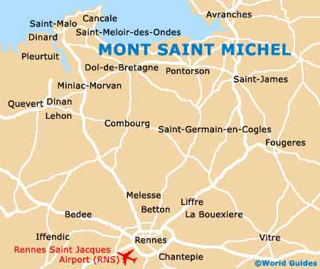
Located in France's northerly Normandy region and lying directly south of
England, Mont Saint Michel is a particularly famous tidal island. Accessed by a causeway during times of low tide, the island of Mont Saint Michel can be found approximately 1 km / 0.5 miles from the mainland, next to the opening of the River Couesnon.
The closest town to Mont Saint Michel is Pontorson, which is located around 8 km / 5 miles to the south of the island. This tends to be where most tourists base themselves and the town can be reached along the D976 road, which links the causeway with Pontorson's central Rue du Couesnon.
Maps and Orientation of the Island
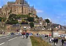
Every year, thousands of visitors flock to Mont Saint Michel to visit its historical abbey and explore the island. There is just one single street on the Mont itself, which is named the 'Grande Rue'. A series of gift shops, hotels and restaurants line the Grande Rue and this street is often to be seen brimming with tourists.
The Mont St. Michel tourist office is located within the Porte de l'Avancée and detailed maps of the Mont can be purchased here for a relatively small charge. It is also worth noting that an up-to-date list of tide times, known as the 'horaire des marées', is always posted outside.
Mont St. Michel Tourist Office / Office de Tourisme
Address: Mont St. Michel, FR-50170, France, FR
Tel: +33 02 3360 1430
Email: ot.mont.st.michel.pontorson@wanadoo.fr
Open hours: daily, July and August - 09:00 to 19:00; September to June - 09:00 to 12:00, 14:00 to 17:30
Pontorson Tourist Office
Address: Place de l'Eglise, Pontorson, FR-50170, France, FR
Tel: +33 02 3360 2065
Email: tourisme.pontorson@wanadoo.fr
Open hours: April to September, Monday to Friday - 09:00 to 12:00, 14:00 to 19:00, Saturday - 10:00 to 12:00, 15:00 to 18:00, Sunday - 10:00 to 12:00; October to March, Monday to Friday - 09:00 to 12:00, 14:00 to 18:00, Saturday - 10:00 to 12:00, 15:00 to 18:00
- Caen - 122 km / 76 miles (one hour and 20 minutes, north-east)
- Cherbourg - 170 km / 105 miles (two hours, north)
- Dieppe - 308 km / 191 miles (three hours, north-east)
- Flers - 84 km / 52 miles (one hour and 15 minutes, east)
- Fougeres - 50 km / 31 miles (48 minutes, south)
- Granville - 47 km / 29 miles (50 minutes, north)
- Guernsey - 125 km / 78 miles (four hours, north)
- Jersey - 74 km / 46 miles (three hours, north)
- Lamballe - 95 km / 59 miles (one hour and 15 minutes, west)
- Laval - 95 km / 59 miles (one hour and 35 minutes, south)
- Le Havre - 215 km / 134 miles (two hours and 25 minutes, north-east)
- Le Mans - 177 km / 110 miles (two hours and 15 minutes, south-east)
- Nantes - 191 km / 119 miles (two hours and 20 minutes, south)
- Paris - 357 km / 222 miles (three hours and 30 minutes, east)
- Pontorson - 8 km / 5 miles (10 minutes, south)
- Rennes - 84 km / 52 miles (one hour and 15 minutes, south)
- Saint-Pair-sur-Mer - 46 km / 29 miles (50 minutes, north)
- St. Malo - 55 km / 34 miles (50 minutes, west)
Map of France

Map of Mont Saint Michel