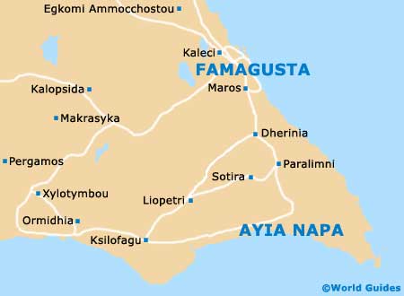
Famagusta Maps and Orientation
(Famagusta, Cyprus)
A popular seaside resort on the far eastern side of
Cyprus, Famagusta stands close to
Ayia Napa and to the north, where it has become the capital of the spreading Famagusta District. The city is located alongside a scenic bay and between the Cape Greco (Cavo Greco) area and Eloea.
Famagusta boasts the deepest harbour on Cyprus and in the 1960s and early 1970s, this area was actually the most popular tourist destination on the whole of Cyprus, with huge numbers of tourists flocking to the neighbouring Varosia resort. However, following the Turkish invasion of 1974 on North Cyprus, Famagusta has taken on a very different appearance, being a much more low key, crumbling version of its former self.
Maps and Orientation of the City
It really is quite simple to find your way around Famagusta and maps are not really necessary, since most of the attractions lie within the historic Old Town area. The Istiklal Caddesi is a prominent thoroughfare in Old Town Famagusta, being fully pedestrianised and connecting the Namik Kemal Maydani square, next to the Lala Mustafa Pasha Mosque.
Long-distance bus transport regularly arrives in Famagusta, at the Otobus Terminal, which is located on the Gazi Mustafa Kemal Bulvari, on the westerly edge of the Old Town. Minibuses arriving in Famagusta tend to use the Itimat bus station, to the south-east and off the Yirmisekiz Ocak Meydani. This imposing public square is an important part of the town and is dominated by a huge statue of Mustafa Kemal Ataturk (1881 to 1938), the founder of
Turkey.
- Akdogan - west
- Angastina - north-west
- Arsos - west
- Athna - south-west
- Ayia Napa (Agia Napa / Aya Napa) - south
- Bogaz - north
- Kondea - west
- Kouklia - west
- Ksilofagu - south-west
- Kyrenia (Keryneia / Girne) - far north-west
- Kythrea - north-west
- Larnaca (Larnaka) - south-west
- Limassol (Lemesos / Limasol / Leymosun) - far south-west
- Lysi - west
- Monastir - north-west
- Mora - north-west
- Nicosia (Lefkosia) - west
- Paphos (Pafos / Paphus) - far south-west
- Paralimni - south
- Prastio - north-west
- Ulukisia - north-west
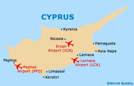
Map of Cyprus
Map of Famagusta