Orlando Maps and Orientation
(Orlando, Florida - FL, USA)
Located in central Florida and particularly near to
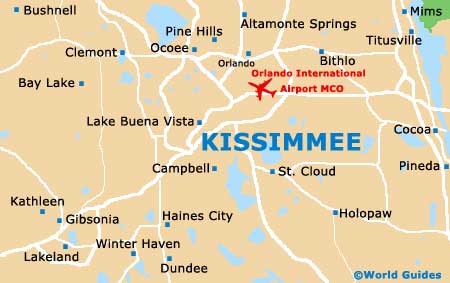
Kissimmee, Orlando also resides within relatively close proximity to both
Daytona Beach (northeast) and
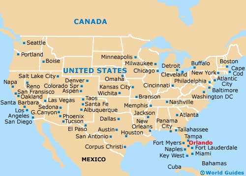
Tampa (southwest). Orlando is to be found within Orange County, where it is the county seat, with its spreading metropolitan area ranking within America's 30 biggest list.
In excess of 50 million tourists now head to Orlando each year, meaning that this city has developed an excellent infrastructure, with an organized network of roads and numerous tourist magnets. However, many of these are a little spread out, meaning that a rental car and a map will make traveling around a lot easier than perhaps relying upon public transport.
Those who have chosen to base themselves in neighboring Kissimmee will find that this suburb city is easy to reach by simply following the Ronald Reagan Turnpike / Florida's Turnpike (SR-91), which heads in a southerly direction. The Spessard L. Holland East-West Expressway (SR-408) heads both east and west, while the Interstate I-4 connects north Florida.
Maps and Orientation of the City
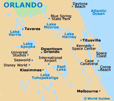
Lying on the southwestern side of the city, International Drive connects a number of Orlando's principal attractions, including the Wet 'n' Wild water park, the Gator Golf Adventure Park and the Festival Bay Mall. The extremely popular Universal Studios attraction lies on the Universal Boulevard, just off International Drive, and is where you will find the Wizarding World of Harry Potter.
If you are driving along International Drive, then it may well make sense to stop off at Orlando's Official Visitor Center to pick up some maps and find out more about the theme parks on offer in Florida.
- Altamonte Springs - 11 miles / 18 km (20 minutes, north)
- Apopka - 18 miles / 29 km (30 minutes, northwest)
- Daytona Beach - 56 miles / 90 km (one hour and 25 minutes, northeast)
- Deltona - 31 miles / 50 km (45 minutes, northeast)
- Hal Scott Regional Preserve and Park - 27 miles / 43 km (40 minutes, east)
- Hunters Creek - 15 miles / 24 km (25 minutes, south)
- Kissimmee - 23 miles / 37 km (40 minutes, south)
- Lake Apopka Restoration Area - 38 miles / 61 km (one hour, northwest)
- Lake Butler - 20 miles / 32 km (35 minutes, west)
- Lake Louisa State Park - 32 miles / 51 km (45 minutes, west)
- Little Big Econ State Forest - 25 miles / 40 km (40 minutes, northeast)
- Meadow Woods - 14 miles / 23 km (25 minutes, south)
- Mount Plymouth - 30 miles / 48 km (45 minutes, northwest)
- Sanford - 21 miles / 34 km (35 minutes, northeast)
- Tampa - 84 miles / 135 km (one hour and 45 minutes, southwest)
- Wekiva Springs - 15 miles / 24 km (25 minutes, north)
Map of the United States
Map of Florida

Map of Orlando