Valencia Maps and Orientation
(Valencia, Valencian Community, Spain)
Sited on the eastern coast of Spain, the city of Valencia resides within the Autonomous Community of Valencia, on the Costa del Azahar. This is a sizeable Spanish city, boasting a population not far off a million, and as such, getting from place to place will need a little thought and planning, and perhaps a map.
Much of the action in Valencia takes place within the area now edged by the former River Turia, which was redirected southwards following a serious flood in 1957 and the dry riverbed was soon transformed into a lush city park. Further boundaries include the Calles de Colon, the Guillem de Castro and the Xativa area, which combine to mark out the former city walls. This part of Valencia is a distinctive oval shape and covers no less than three major public squares, namely the Plaza del Ayuntamiento, the Plaza de la Reina and the Plaza de la Virgen.
Maps and Orientation of the City
The most historical part of Valencia borders the old Turia Riverbed, the Plaza de la Virgen, the Torres de Quart and the Torres de Serranos. The bus station is close by, on the Avenida Menendez Pidal, while the railway station is just a stroll to the south of the Plaza del Ayuntamiento (Town Hall Square).
Maps of Valencia can be obtained from most hotels, the tourist offices (including outlets on the Calle Paz, at the Town Hall and at the Teatro Principal) and at the railway station.
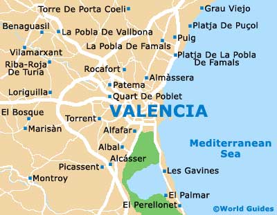
- Albal - 14 km / 9 miles (25 minutes, south)
- Alfafar - 7 km / 4 miles (12 minutes, south)
- Almàssera - 7 km / 4 miles (12 minutes, north)
- El Bosque - 25 km / 16 miles (35 minutes, west)
- La Pobla De Famals - 16 km / 10 miles (25 minutes, north)
- La Pobla De Vallbona - 23 km / 14 miles (35 minutes, north-west)
- Loriguilla - 20 km / 12 miles (30 minutes, west)
- Montroy - 37 km / 23 miles (50 minutes, south-west)
- Picassent - 19 km / 12 miles (30 minutes, south)
- Puig - 18 km / 11 miles (30 minutes, north-east)
- Quart De Poblet - 8 km / 5 miles (15 minutes, west)
- Riba-Roja De Turia - 26 km / 16 miles (35 minutes, north-west)
- Rocafort - 12 km / 7 miles (20 minutes, north)
- Torrent - 11 km / 7 miles (20 minutes, west)
Map of Spain

Map of Valencia