Benidorm Maps and Orientation
(Benidorm, Costa Blanca, Spain)
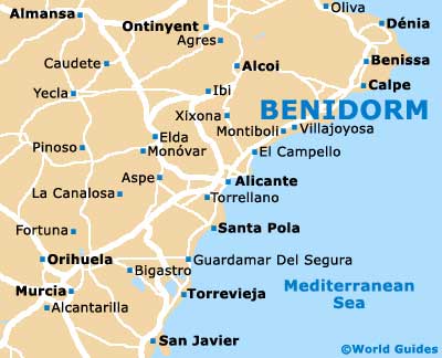
Located within the Valencian province of Alicante, the holiday resort of Benidorm is located on the south-eastern Costa Blanca coastline of Spain, alongside the Western Mediterranean Sea. Just a small seaside town in the sixties, Benidorm was quickly transformed into a busy tourist resort with endless high-rise hotel blocks, following the advent of the package holiday.
Benidorm boasts a number of scenic and popular beaches, with the Playa del Lavante being a real highlight. Many roads run parallel to the beaches, such as the Avenida de Madrid and the Avenida del Mediterraneo, or perpendicular to the coastline, such as both the Avenida de Cuenca and the Avenida de Las Antillas.
Maps and Orientation of the City
Many holiday makers in Benidorm rarely venture far from their hotel's swimming pool or adjacent beachfront, with all-inclusive packages being extremely popular. However, if you choose to rent a car during your visit, you can pick up maps of the Costa Blanca region from either the car rental outlet or one of the plentiful tourist kiosks in town.
- Albacete - 212 km / 132 miles (three hours and 15 minutes, north-west)
- Alcoy - 60 km / 37 miles (one hour and ten minutes, north-west)
- Alicante - 46 km / 29 miles (50 minutes, south-west)
- Almansa - 141 km / 88 miles (two hours and 20 minutes, north-west)
- Benissa - 34 km / 21 miles (40 minutes, north-east)
- Cartagena - 167 km / 104 miles (two hours and 40 minutes, south-west)
- Cullera - 100 km / 62 miles (one hour and 40 minutes, north)
- Denia - 53 km / 33 miles (one hour, north-east)
- Elche - 73 km / 45 miles (one hour and 20 minutes, south-west)
- Elda - 80 km / 50 miles (one hour and 25 minutes, west)
- Gandia - 72 km / 45 miles (one hour and 20 minutes, north)
- Javea - 55 km / 34 miles (one hour, north-east)
- Mazarron - 205 km / 127 miles (three hours and ten minutes, south-west)
- Murcia - 126 km / 78 miles (two hours, south-west)
- Oliva - 68 km / 42 miles (one hour and 15 minutes, north)
- Valencia - 140 km / 87 miles (two hours and 20 minutes, north)
Map of Spain

Map of Benidorm