Tenerife Maps and Orientation
(Tenerife, Canary Islands, Spain)
The island of Tenerife is part of the Canary islands (Islas Canarias) and located within the Atlantic Ocean. Many thousands of holiday makers flock to the beaches of Tenerife each year, a large proportion of which originate from the Iberian Peninsula.
La Gomera is the closest island to Tenerife and lies to the south-west, while La Palma is slightly further away and to the north-west, and
Gran Canaria to the south-east. All of these islands are well connected by regular ferries and flights.
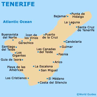
Maps and Orientation of the City
The island is divided into a total of 31 different municipalities, with Santa Cruz de Tenerife serving as the capital city. Santa Cruz is centred around the Plaza Espana, with the majority of sights being no more than a ten-minute walk from this square. Other significant cities and towns include Costa Adeje, La Laguna, La Orotava, Las Americas, Los Cristianos, Los Gigantes and Puerto de la Cruz.
Getting around the island of Tenerife needn't be difficult or expensive, and taxis will take you literally anywhere. However, holiday makers frequently choose to hire a car for a day or week, pickup up some maps and navigate their own way around, from beach to beach. Distances and directions from Santa Cruz are as follows:
- Arico - 48 km / 30 miles (one hour and ten minutes, south-west)
- Bajamar - 29 km / 18 miles (40 minutes, north-west)
- Buenavista del Norte - 70 km / 43 miles (one hour and 15 minutes, west)
- Candelaria - 21 km / 13 miles (30 minutes, south-west)
- Fasnia - 42 km / 26 miles (one hour, south-west)
- Guia de Isora - 88 km / 55 miles (one hour and 40 minutes, south-west)
- Guimar - 29 km / 18 miles (40 minutes, south-west)
- La Escalona - 81 km / 50 miles (one hour and 20 minutes, south-west)
- Los Cristianos - 78 km / 48 miles (one hour and 20 minutes, south-west)
- Los Gigantes - 90 km / 56 miles (one hour and 40 minutes, south-west)
- Puerto de la Cruz - 37 km / 23 miles (50 minutes, west)
- Punta de Hidalgo - 34 km / 21 miles (45 minutes, north)
- San Cristobal de La Laguna - 10 km / 6 miles (15 minutes, west)
- San Miguel - 72 km / 45 miles (one hour and 15 minutes, south-west)
- Santiago del Teide - 78 km / 48 miles (one hour and 30 minutes, south-west)
Map of the Canary Islands

Map of Tenerife