Zaragoza Maps and Orientation
(Zaragoza, Aragon, Spain)
Often also known as Saragossa, the city of Zaragoza resides on the north-eastern side of Spain. Capital of both the autonomous community of Aragon and the Zaragoza Province, the city has played host to many prestigious events over the years, including the Expo 2008.
Zaragoza has a history of more than 2,000 years and therefore there are many breathtaking architectural gems to admire, more than most tourists imagine. Finding your way around will require a map, but keeping an eye out for local landmarks, such as the Ebro River and the Basilica of Our Lady of the Pillar.
Maps and Orientation of the City
The very heart of Old Town Zaragoza resides on the southern banks of the Ebro River, where its former walls are defined by the El Coso and the Avenida de César Augusto. Many eateries, shops and hotels live in this part of the city, being best explored on foot. Tourists walking around Zaragoza should visit the Plaza del Pilar, where you can marvel at some spectacular churches and the alleyways of the El Tubo neighbourhood. Roughly 20 minutes to the west is the Estacion Intermodal Delicias railway station.
If you have a car and are intending to get out and about in the region, then the Pyrenees are roughly two hours away and home to many of Spain's premier ski resorts.
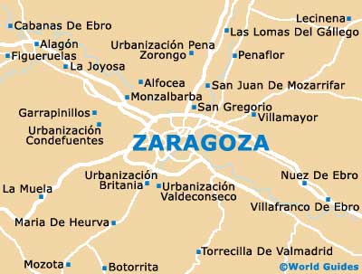
- Alfocea - 16 km / 10 miles (25 minutes, north)
- Botorrita - 24 km / 15 miles (35 minutes, south-west)
- Garrapinillos - 19 km / 12 miles (30 minutes, west)
- La Joyosa - 23 km / 14 miles (35 minutes, north-west)
- La Muela - 28 km / 17 miles (40 minutes, south-west)
- Lecinena - 33 km / 21 miles (45 minutes, north-east)
- Monzalbarba - 14 km / 9 miles (25 minutes, north)
- Nuez De Ebro - 25 km / 16 miles (35 minutes, south-east)
- Penaflor - 17 km / 11 miles (30 minutes, north)
- San Gregorio - 6 km / 4 miles (ten minutes, north)
- San Juan De Mozarrifar - 10 km / 6 miles (15 minutes, north)
- San Sebastian - 264 km / 164 miles (four hours, north-west)
- Torrecilla De Valmadrid - 23 km / 14 miles (35 minutes, south)
- Villafranco De Ebro - 27 km / 17 miles (40 minutes, south-east)
- Villamayor - 13 km / 8 miles (20 minutes, north-east)
Map of Spain

Map of Zaragoza