Ayia Napa Maps and Orientation
(Ayia Napa, Famagusta, Cyprus)
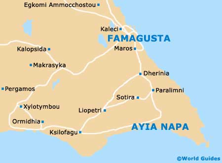
Located on the far eastern side of the sunny south coast, Ayia Napa is a leading seaside resort town in this region of
Cyprus, being famed for its beaches and nightlife. Ayia Napa stands next to the Cape Greco (Cavo Greco) headland and the Famagusta Bay, and is located within the official Famagusta District, where it is part of the Kokkinochoria area of Cyprus.
Close to the town of Protaras, where the popular resort of Paralimni is located, Ayia Napa has enjoyed much redevelopment in recent years. The town's popularity with tourists is very much due to its plentiful sandy beaches and beautiful coastal scenery.
Maps and Orientation of the Town / Resort
One of the main streets in Ayia Napa is the Leoforos Nisiou, which runs in an east to west direction, towards nearby
Larnaca. At the eastern end of the Leoforos Nisiou, the other main street is the Leoforos Arhiepiskopou Makariou III, which heads north to south, near to the harbour.
Central to life in Ayia Napa is the Plateia Seferi, which is perhaps better known simply as 'the Square'. A number of different roads run of the Square, such as the Leoforos Kryou Nerou, which leads to an office of the Cyprus Tourist Organisation (CTO), where island maps are available.
- Akdogan - north-west
- Aloa - north-west
- Arsos - north-west
- Athienou - north-west
- Athna - north-west
- Famagusta (Ammóchostos / Gazimagusa) - north
- Kondea - north-west
- Kouklia - north-west
- Ksilofagu - west
- Kyrenia (Keryneia / Girne) - far north-west
- Larnaca (Larnaka) - south-west
- Lefkoniko - north-west
- Limassol (Lemesos / Limasol / Leymosun) - far south-west
- Lysi - north-west
- Nicosia (Lefkosia) - north-west
- Paphos (Pafos / Paphus) - far south-west
- Paralimni - north
- Pernera - north
- Prastio - north-west
- Protaras - north
- Pyroi - north-west
- Troulli - north-west
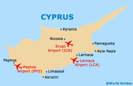
Map of Cyprus
Map of Ayia Napa