Los Angeles Maps and Orientation
(Los Angeles, California - CA, USA)
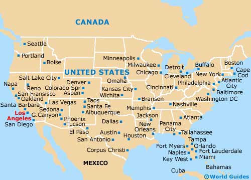
A city of sunshine and celebrities, Los Angeles is one of the most famous of all the cities located on the southern side of the state of California, in between
Anaheim and
Santa Monica. Los Angeles is actually the largest city in California - by far, although it is
Sacramento that serves as the state capital.
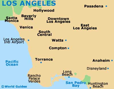
Visitors to Los Angeles will soon realize that the city is more like a collection of sizeable towns, centered around a downtown core. These neighborhoods include the likes of Arlington Heights, Baldwin Hills, Bel-Air, Beverly Hills, Echo Park, Fairfax, Harbor City, Hollywood, Melrose Hill, Mount Washington, Pacific Palisades and West Adams, amongst many others.
Downtown Los Angeles is home to some spectacular architecture and numerous cultural attractions, being located roughly 12 miles / 19 km inland. Within the downtown district are a series of communities, such as Chinatown, Little Tokyo and Olvera Street.
Maps and Orientation of the City
To the northeast, the suburb of Pasadena has much to offer tourists, with its botanical gardens and outdoor athletics stadium known simply as the Rosebowl. To the northwest of downtown Los Angeles, Hollywood is synonymous with the world's movie industry and a regular haunt of film stars, being home to film studios, and the hilly neighborhoods of both Los Fello and Silver Lake. Additional studios now reside further north of Hollywood, in San Fernando Valley.
Head to the south of Hollywood and you will soon reach the ever-popular Museum Row, with affluent Beverly Hills being to the west of this spot. For maps of Los Angeles and general tourist attraction leaflets, local shops, supermarkets and even gas stations are a good bet, while for beaches and seaside fun,
Long Beach, Malibu, Santa Monica and Venice all stand out.
- Anaheim - 26 miles / 42 km (40 minutes, southeast)
- Burbank - 12 miles / 19 km (20 minutes, north)
- Culver City - 10 miles / 16 km (15 minutes, west)
- Diamond Bar - 29 miles / 47 km (45 minutes, east)
- Glendale - 8 miles / 13 km (12 minutes, north)
- Hawthorne - 15 miles / 24 km (25 minutes, southwest)
- Inglewood - 13 miles / 21 km (20 minutes, southwest)
- Long Beach - 25 miles / 40 km (40 minutes, south)
- Palm Springs - 107 miles / 172 km (two hours and 50 minutes, east)
- Pasadena - 11 miles / 18 km (20 minutes, northeast)
- San Diego - 121 miles / 195 km (three hours and 15 minutes, southeast)
- Santa Barbara - 95 miles / 153 km (two hours and 20 minutes, northwest)
- Santa Clarita - 31 miles / 50 km (50 minutes, northwest)
- Santa Monica - 16 miles / 26 km (25 minutes, west)
- Simi Valley - 41 miles / 66 km (one hour and five minutes, northwest)
- Thousand Oaks - 40 miles / 64 km (one hour and five minutes, northwest)
- West Covina - 19 miles / 31 km (35 minutes, east)
Map of the United States
Map of California

Map of Los Angeles