Montego Bay Maps and Orientation
(Montego Bay, St. James, Cornwall, Jamaica)
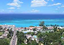
Located within the St. James Parish, where it is the capital city, Montego Bay lies on the north-western coast of
Jamaica and is the country's second-biggest city, with a population of approximately 120,000 people. The city of Montego Bay not only enjoys a stunning coastal setting, but also a very scenic backdrop provided by a series of low mountains.
Gloucester Avenue serves as an important thoroughfare in Montego Bay and is lined with a good choice of hotels, eateries and bars. This vibrant road runs alongside the beachfront and is always filled with tourists. It is here that the Jamaica Tourist Board is situated, just across from Cornwall Beach. Open Monday to Friday, between 08:30 and 16:30, and on Saturdays from 09:00 until 13:00, this outlet is one of the best sources of city maps and guide brochures.
Maps and Orientation of the City
Downtown Montego Bay is very much centred around Sam Sharpe Square, which fans outwards to create a gridwork of streets. Many attractive Georgian buildings are spread around the downtown area, although a large proportion are in need of renovation work to restore them to their former glory.
The following list shows the main destinations on Jamaica and their respective times and distances from Montego Bay:
- Albert Town - 82 km / 51 miles (one hour and 30 minutes, south-east)
- Alligator Pond - 110 km / 68 miles (two hours, south-east)
- Black River - 66 km / 41 miles (one hour and 15 minutes, south)
- Discovery Bay - 69 km / 43 miles (one hour and 15 minutes, east)
- Falmouth - 35 km / 22 miles (40 minutes, east)
- Kingston - 181 km / 112 miles (three hours and 15 minutes, south-east)
- Lucea - 37 km / 23 miles (40 minutes, west)
- Mandeville - 110 km / 68 miles (two hours, south-east)
- May Pen - 146 km / 91 miles (two hours and 30 minutes, south-east)
- Morant Bay - 234 km / 145 miles (four hours and 15 minutes, south-east)
- Negril - 77 km / 48 miles (one hour and 20 minutes, south-west)
- Ocho Rios - 103 km / 64 miles (one hour and 40 minutes, east)
- Port Antonio - 198 km / 123 miles (three hours and 30 minutes, east)
- Port Maria - 135 km / 84 miles (two hours and 20 minutes, east)
- Portmore - 192 km / 119 miles (three hours and 25 minutes, south-east)
- Saint Ann's Bay - 91 km / 57 miles (one hour and 30 minutes, east)
- Savanna-la-Mar - 50 km / 31 miles (55 minutes, south-west)
- Spanish Town - 184 km / 114 miles (three hours and 15 minutes, south-east)
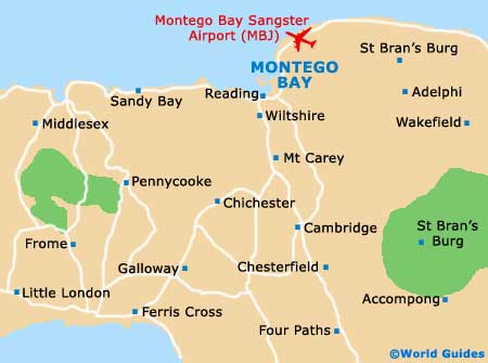
Map of Jamaica

Map of Montego Bay