Paraty Maps and Orientation
(Paraty, Rio de Janeiro, Brazil)
Situated on the south-eastern side of
Brazil and within the state of Rio de Janeiro, the small coastal town of Paraty lies next to the Bay of Ilha Grande and near to a series of small tropical islands. Paraty was founded in the 16th century and enjoys a particularly scenic backdrop, which rises up more than 1,000 metres / 3,280 feet and comprises a mixture of lush forests, waterfalls and mountains.
Many green spaces surround Paraty, with the most prominent of these including both the Serra do Mar State Park and the Serra da Bocaina National Park, as well as the Joatinga Reserve.
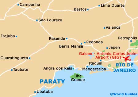
Maps and Orientation of the Town
The northern side of Paraty is bounded by the Rio Pereque Acu (Pereque Acu River), which is spanned by the Rua Pontal / Rua do Comercio. Most visitors will not find the need for maps, since Paraty is relatively small, compact and easy to get around, although the street names can be a little confusing at times, since some are known by several different names. Also of note, house numbers do not always follow a logical order.
- Angra dos Reis - 97 km / 60 miles (one hour and 40 minutes, north-east)
- Barra Mansa - 159 km / 99 miles (two hours and 55 minutes, north-east)
- Belford Roxo - 226 km / 140 miles (three hours and 40 minutes, north-east)
- Belo Horizonte - 590 km / 367 miles (eight hours and 45 minutes, north)
- Caraguatatuba - 125 km / 78 miles (two hours and ten minutes, south-west)
- Contagem - 603 km / 375 miles (nine hours, north)
- Duque de Caxias - 236 km / 147 miles (four hours, north-east)
- Mangaratiba - 146 km / 91 miles (two hours and 40 minutes, north-east)
- Mesquita - 225 km / 140 miles (three hours and 40 minutes, north-east)
- Mogi das Cruzes - 238 km / 148 miles (four hours, west)
- Nova Iguacu - 221 km / 137 miles (three hours and 30 minutes, north-east)
- Queimados - 208 km / 129 miles (three hours and 20 minutes, north-east)
- Rio Claro - 125 km / 78 miles (two hours and ten minutes, north-east)
- Rio de Janeiro - 240 km / 149 miles (four hours, east)
- Santos - 344 km / 214 miles (five hours and 30 minutes, south-west)
- Sao Joao de Meriti - 231 km / 144 miles (four hours, north-east)
- Sao Paulo - 290 km / 180 miles (four hours and 25 minutes, west)
- Seropédica - 192 km / 119 miles (three hours and 15 minutes, north-east)
- Ubatuba - 74 km / 46 miles (one hour and 20 minutes, south-west)
- Volta Redonda - 169 km / 105 miles (three hours and ten minutes, north-east)
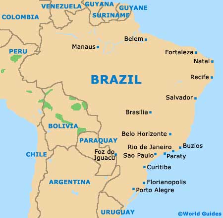
Map of Brazil
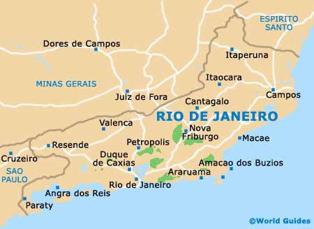
Map of Rio de Janeiro State
Map of Paraty