San Sebastian Maps and Orientation
(Donostia - San Sebastian, Gipuzkoa, Basque Country, Spain)
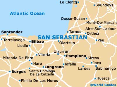
San Sebastian is located on the north-eastern coast of Spain, where it resides within the autonomous community of the Basque Country and fronts the Bay of Biscay. Visitors don't often realise just how close to
France the city of San Sebastian is, with the French border being just 20 km / 12 miles, where nearby Biarritz and Bayonne are highlights.
Capital of the Gipuzkoa (Guipuzcoa) province, San Sebastian is called home by some 194,00 people and is officially known to the Spanish as Donostia-San Sebastián. The city can become extremely busy when major events are in town, such as the International Film Festival each September, and so there can often be much competition for accommodation.
Maps and Orientation of the City
Finding your way around San Sebastian is made all the more easy if you possess a map or two. Bear in mind that the city has principal clusters of activity. The Old Town (Parte Vieja) is where it all happens, being located just beneath the Monte Urgull Paruqe and on the easterly side of the Bahia de la Conchha.
The considerably more modern heart of San Sebastian resides around the Catedral del Buen Pastor, on the Plaza del Buen Pastor, while head to the east and across the River Urumea and you will reach the neighbourhood of Gros, where reliable hotels, popular restaurants and tempting beaches are all good reasons why you might like to base yourself here.
- Bilbao - 98 km / 61 miles (one hour and 15 minutes, west)
- Burgos - 214 km / 133 miles (two hours and 45 minutes, south-west)
- Haro - 143 km / 89 miles (one hour and 55 minutes, south-west)
- Huesca - 248 km / 154 miles (three hours and 30 minutes, south-east)
- Llodio - 109 km / 68 miles (one hour and 25 minutes, south-west)
- Oiartzun - 14 km / 9 miles (20 minutes, east)
- Ousse-Suzan - 60 km / 37 miles (45 minutes, north-east)
- Pamplona - 82 km / 51 miles (one hour and five minutes, south)
- Santander - 196 km / 122 miles (two hours and ten minutes, west)
- Tafalla - 122 km / 76 miles (one hour and 45 minutes, south)
- Torrelavega - 210 km / 130 miles (two hours and 35 minutes, west)
- Vitoria - 103 km / 64 miles (one hour and 25 minutes, south-west)
- Zaragoza - 264 km / 164 miles (four hours, south-east)
Map of Spain

Map of San Sebastian