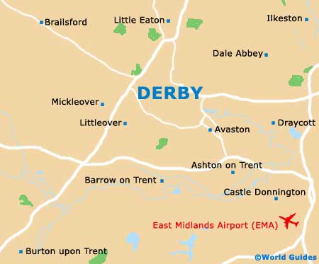
Derby Maps and Orientation
(Derby, Derbyshire, England, UK)
Located in the East Midlands area of central
England, the city of Derby resides in the county of Derbyshire. Lying alongside the River Derwent and particularly close to
Nottingham, Derby is known for its lively Cathedral Quarter, which offers a memorable shopping experience and plenty of street cafes.
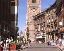
Much of central Derby contains some rather characterless pedestrianised streets, while the historical area of the city is considerably more appealing, with the partially cobble stretch known as the Iron Gate (Irongate) being extremely attractive. The Iron Gate leads to the cathedral and is sandwiched between Queen Street and the Cornmarket, being a good place to start to familiarise yourself with the city centre.
Maps and Orientation of the City
A couple of small streets connect with the Iron Gate and are lined with pubs and cafes, providing a good place to stop for a bite to eat. There are also a selection of specialist shops in this part of Derby, selling everything from designer clothing to handmade jewellery and surf gear.
For maps of Derby, pay a visit to the tourist information centre at the Market Place, which is open Monday to Friday - 09:30 to 17:30, Saturday - 09:30 to 17:00 and Sunday - 10:30 to 14:30.
- Alfreton - 24 km / 15 miles (30 minutes, north)
- Ashbourne - 21 km / 13 miles (25 minutes, north-west)
- Bakewell - 48 km / 30 miles (50 minutes, north-west)
- Birmingham - 74 km / 46 miles (one hour and ten minutes, south-west)
- Borrowash - 8 km / 5 miles (ten minutes, east)
- Buxton - 61 km / 38 miles (one hour, north-west)
- Cannock - 74 km / 46 miles (one hour and ten minutes, south-west)
- Carlton - 29 km / 18 miles (33 minutes, east)
- Castle Donington - 16 km / 10 miles (15 minutes, south-east)
- Chesterfield - 48 km / 30 miles (45 minutes, north)
- Coventry - 83 km / 52 miles (one hour and 15 minutes, south)
- Draycott - 13 km / 8 miles (15 minutes, east)
- Foston - 23 km / 14 miles (30 minutes, west)
- Hucknall - 30 km / 19 miles (35 minutes, north-east)
- Ilkeston - 18 km / 11 miles (23 minutes, east)
- Ingleby - 13 km / 8 miles (20 minutes, south)
- Kilburn - 11 km / 7 miles (12 minutes, north)
- Long Eaton - 16 km / 10 miles (17 minutes, east)
- Loughborough - 35 km / 22 miles (40 minutes, south-east)
- Mansfield - 37 km / 23 miles (40 minutes, north-east)
- Matlock - 36 km / 22 miles (35 minutes, north)
- Nottingham - 26 km / 16 miles (30 minutes, east)
- Nuneaton - 67 km / 42 miles (one hour, south)
- Ripley - 19 km / 12 miles (20 minutes, north)
- Sheffield - 77 km / 48 miles (one hour and ten minutes, north)
- Solihull - 77 km / 48 miles (one hour and ten minutes, south-west)
- Stapleford - 16 km / 10 miles (15 minutes, east)
- Stoke on Trent - 61 km / 38 miles (55 minutes, north-west)
- Swadlincote - 24 km / 15 miles (30 minutes, south)
- Tamworth - 46 km / 29 miles (50 minutes, south)
- Uttoxeter - 34 km / 21 miles (35 minutes, west)
- Walsall - 56 km / 35 miles (55 minutes, south-west)
- Wolverhampton - 70 km / 44 miles (one hour and five minutes, south-west)
Map of the United Kingdom

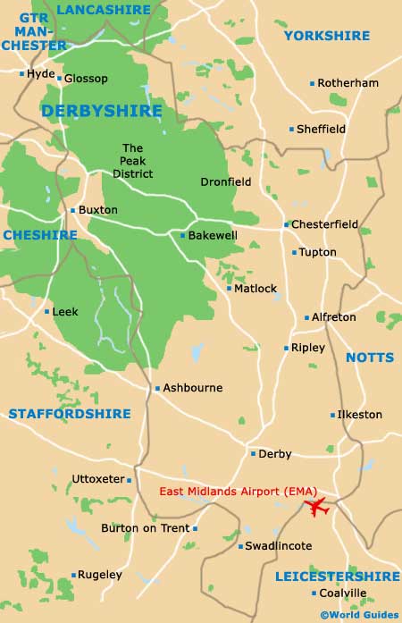
Map of Derbyshire
Map of Derby