Pittsburgh Maps and Orientation
(Pittsburgh, Pennsylvania - PA, USA)
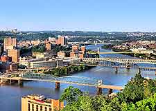
The second-biggest of all the cities in Pennsylvania, Pittsburgh lies within Allegheny County, where it has become the county seat. Close to the Ohio border and boasting a population now exceeding 350,000 people, Pittsburgh is now a busy and modern city, filled with high-rise structures and tall skyscrapers, many of which reflect in the city's waterfront, where both the Allegheny River (northeast) and Monongahela River (southeast) converge to form the actual Ohio River.
Life in Pittsburgh is very much based around its rivers and therefore the city is filled with bridges, so many in fact that it is often referred to as the 'City of Bridges'. The recently renovated downtown district is sandwiches between the riverfronts and this part of the city has gained the name of the 'Golden Triangle'. Close by, the Point State Park lies at the very confluence of the rivers and is known by local Pennsylvanians as 'The Point'.
Maps and Orientation of the City
The city of Pittsburgh is set within a sloping valley, meaning that some areas are quite steep and sloping, particularly those neighborhoods on the northern side of the city, and also on the southern side of the Monongahela River.
Just a stone's throw to the north of downtown Pittsburgh is the Strip, where many warehouses and restaurants are to be found, along streets such as Penn Avenue and Smallman Avenue. The North Side is also home to some very large sports stadiums and museums, which are close to the Allegheny Square. Other areas include the East End, the South Side and the West End.
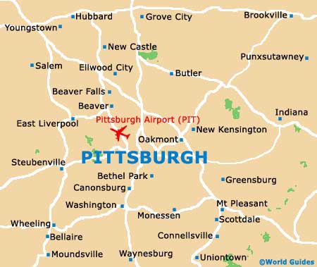
Maps are always useful and available from a number of bookstores along 5th Avenue and Murray Avenue, at the airport, and also at the Pittsburgh Convention and Visitors Bureau on Liberty Avenue. The following destinations are shown in relation to Pittsburgh city:
- Akron (Ohio) - 106 miles / 171 km (one hour and 55 minutes, northwest)
- Alliance (Ohio) - 83 miles / 134 km (one hour and 45 minutes, northwest)
- Altoona - 96 miles / 154 km (two hours and five minutes, east)
- Beaver - 37 miles / 60 km (50 minutes, northwest)
- Butler - 41 miles / 66 km (one hour, north)
- Canton (Ohio) - 91 miles / 147 km (two hours and five minutes, west)
- Cincinnati (Ohio) - 288 miles / 463 km (four hours and 45 minutes, southwest)
- Cleveland (Ohio) -133 miles / 214 km (two hours and 20 minutes, northwest)
- Columbus (Ohio) - 185 miles / 298 km (three hours and ten minutes, west)
- Detroit (Michigan) - 282 miles / 454 km (four hours and 40 minutes, northwest)
- Erie - 128 miles / 206 km (two hours and ten minutes, north)
- Greensburg - 35 miles / 56 km (50 minutes, southeast)
- Indiana - 60 miles / 97 km (one hour and 25 minutes, east)
- Johnstown - 69 miles / 111 km (one hour and 40 minutes, east)
- Lexington (Kentucky) - 370 miles / 595 km (six hours, southwest)
- McKeesport - 14 miles / 23 km (25 minutes, southeast)
- Monroeville - 13 miles / 21 km (25 minutes, east)
- New Castle - 53 miles / 85 km (one hour and five minutes, north)
- Philadelphia - 305 miles / 491 km (five hours, east)
- Toronto (Ontario, Canada) - 317 miles / 510 km (five hours and 15 minutes, north)
- Washington (DC) - 245 miles / 394 km (four hours and 15 minutes, southeast)
- Wheeling (West Virginia) - 59 miles / 95 km (one hour and 10 minutes, southwest)
- Youngstown (Ohio) - 66 miles / 106 km (one hour and 15 minutes, north)
Map of the United States

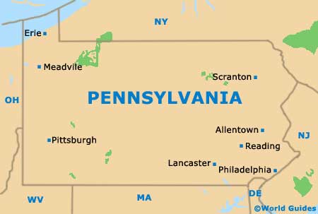
Map of Pennsylvania
Map of Pittsburgh