Cincinnati Maps and Orientation
(Cincinnati, Ohio - OH, USA)
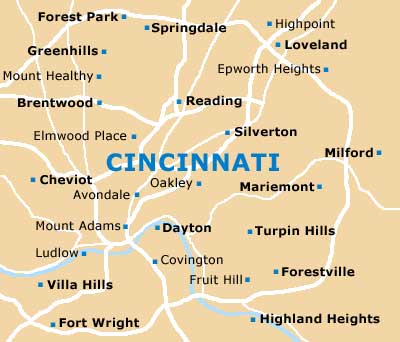
Located within the state of Ohio and alongside the Ohio River, Cincinnati serves as Hamilton County's administrative center (county seat). Close to
Indiana and the border with
Kentucky, Cincinnati is centered around its busy downtown district, where Fountain Square forms the centerpiece, with its famous 'Spirit of the Waters' fountain and seasonal ice-skating rink.
Lying above the downtown district and to the east is the Mount Adams neighborhood, a 19th-century district with winding streets and numerous eateries.
Vine Street is a notable road and heads roughly in a north to south direction, dividing the city into east / west regions. If you are planning to find your way around Cincinnati, it is worth noting that streets running east to west are numbered, while intersecting north to south streets are all named.
Maps and Orientation of the City
On the southern side of the city, the Ohio River forms a boundary to Kentucky, being crossed by the Brent Spence Bridge (I-71 and I-75), the Clay Wade Bailey Bridge and the Daniel Carter Beard Bridge I-471, as well as the Roebling Suspension Bridge and the iconic Purple People Bridge. The small suburb cities of both Covington and Newport lie across the river in neighboring Kentucky.
Tourists planning to navigate their way around Cincinnati will find that the Visitors Center on Walnut Street is a good place to pick up maps. This tourist information office stands next to Fountain Square and just across from the Carew Tower, roughly three blocks away from the Convention Center.
- Bridgetown North - 9 miles / 14 km (15 minutes, west)
- Covington - 2 miles / 3 km (five minutes, south)
- Dayton - 54 miles / 87 km (one hour and 20 minutes, northeast)
- Forest Park - 18 miles / 29 km (30 minutes, north)
- Hamilton - 32 miles / 51 km (45 minutes, north)
- Independence - 16 miles / 26 km (25 minutes, south)
- Kenwood - 13 miles / 21 km (22 minutes, northeast)
- Latonia - 6 miles / 10 km (12 minutes, south)
- Lawrenceburg - 26 miles / 42 km (40 minutes, west)
- Lexington - 84 miles / 135 km (two hours, south)
- Louisville - 99 miles / 159 km (two hours and 25 minutes, southwest)
- Middletown - 38 miles / 61 km (55 minutes, northeast)
- Milford East - 15 miles / 24 km (25 minutes, east)
- Taylor Mill - 10 miles / 16 km (15 minutes, south)
- West Chester - 23 miles / 37 km (40 minutes, northeast)
Map of the United States
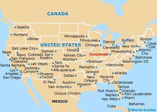
Map of Ohio

Map of Cincinnati