Tampa Maps and Orientation
(Tampa, Florida - FL, USA)
Currently the third-biggest of all the cities in Florida, Tampa resides on the state's western coast, being located to the northeast of
Sarasota and to the southwest of
Orlando. This waterfront city resides alongside Sarasota Bay, within Hillsborough County, where it functions as the county seat.
The city belongs to an expansive metropolitan region named the Tampa Bay Area, which boasts a population close to three million and comprises the cities of Brandon, Clearwater and also St. Petersburg.
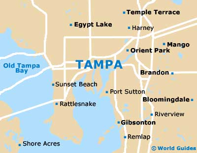
Regularly appearing on lists of appealing outdoor cities and those with a youthful vibe, Tampa is a city of districts. The centrally located downtown district is the hub of activity and interest, while the northeasterly Ybor City celebrates the city's long association with the Cuban cigar industry.
Maps and Orientation of the City
Knowing where the principal districts are will certainly help you find your way around Tampa, particularly when asking for directions.
Local maps may prove beneficial if you are heading somewhere in particular. Maps are available from the Tampa Bay Convention and Visitor Bureau, the airport, and bookstores on streets such as South Armenia Avenue, East Fletcher Avenue (close to the University of South Florida), the North Dale Mabry Highway (in the northerly Carrollwood area) and the West Kennedy Boulevard.
- Apollo Beach - 19 miles / 31 km (35 minutes, south)
- Bloomingdale - 17 miles / 27 km (30 minutes, southeast)
- Brandon - 13 miles / 21 km (25 minutes, east)
- Clearwater - 23 miles / 37 km (40 minutes, west)
- East Lake - 24 miles / 39 km (40 minutes, northwest)
- Egypt Lake - 7 miles / 11 km (12 minutes, north)
- Gibsonton - 11 miles / 18 km (20 minutes, southeast)
- Greater Carrollwood - 11 miles / 18 km (20 minutes, north)
- Greater Northdale - 11 miles / 18 km (20 minutes, north)
- Kissimmee - 75 miles / 121 km (one hour and 45 minutes, east)
- Lake Magdalene - 10 miles / 16 km (20 minutes, north)
- Largo - 23 miles / 37 km (40 minutes, west)
- Orlando - 84 miles / 135 km (one hour and 45 minutes, northeast)
- Palm Harbor - 29 miles / 47 km (45 minutes, northwest)
- Pebble Creek - 21 miles / 34 km (35 minutes, northeast)
- Sarasota - 60 miles / 97 km (one hour and 30 minutes, southwest)
- St. Petersburg - 37 miles / 60 km (one hour and five minutes, north)
- Temple Terrace - 11 miles / 18 km (20 minutes, northeast)
- Thonotosassa - 15 miles / 24 km (25 minutes, northeast)
- Westchase - 17 miles / 27 km (30 minutes, northwest)
Map of the United States
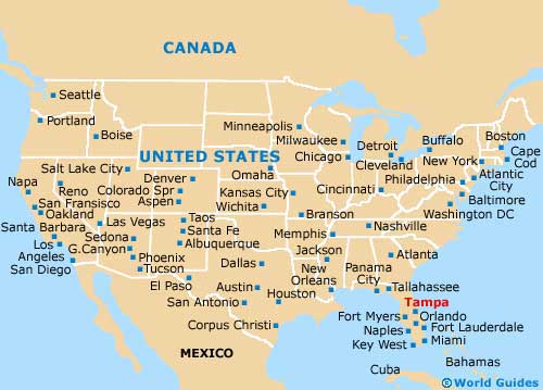
Map of Florida

Map of Tampa