Cabo San Lucas Maps and Orientation
(Cabo San Lucas, Baja California Sur, Mexico)
A small and inviting city located on the far southerly end of the Mexican Baja California peninsula, Cabo San Lucas lies in the Los Cabos area and within the Mexican state of Baja California Sur. Cabo San Lucas is currently riding on the crest of a popularity wave and in recent years has become a luxury holiday resort, with exceptional facilities and a stunning coastline.
Despite is relatively small size and population of around 55,000 residents, Cabo San Lucas has plenty to offer in the way of tourism and contains a number of apartment blocks, timeshares and marinas.
Maps and Orientation of the City
On the north-western side of Cardenas, central Cabo San Lucas boasts a fairly regular and organised grid. Nearby and to the south-east, the Boulevard Marina is much more freeform and follows a curving line as it approaches the harbour and Land's End, the very tip of the peninsula, next to the Playa del Amor and close to the Playa Solmar. It is at this part of Cabo San Lucas where the Sea of Cortez and the neighbouring Pacific Ocean actually converge.
Simple maps of Cabo San Lucas are also useful and readily available all around the city. Maps are particularly plentiful along the Boulevard Marina, being distributed by time-share marketers trying to promote interest, so do be prepared for a sales pitch of some kind.
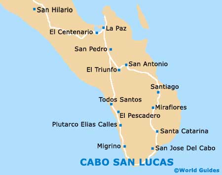
- El Pescadeo - north-west
- La Palma - north
- La Paz - north
- Migrino - north
- Miraflores - north
- Palmilla - north-east
- Plutarco Elias Callés - north-west
- Pozo De Cota - north-west
- San Jose Del Cabo - north-east
- San Pedro - north
- Santa Anita - north-east
- Santiago - north
- Todos Santos - north-west
Map of Mexico

Map of Cabo San Lucas