Lanzarote Maps and Orientation
(Lanzarote, Canary Islands, Spain)
The fourth-largest of the Canary Islands, after
Tenerife,
Fuerteventura and
Gran Canaria, the island of Lanzarote is surrounded by the Atlantic Ocean. Lanzarote is the furthest east of all the Spanish Canaries and is only 125 km / 78 miles from the African coastline (Western Sahara /
Morocco).
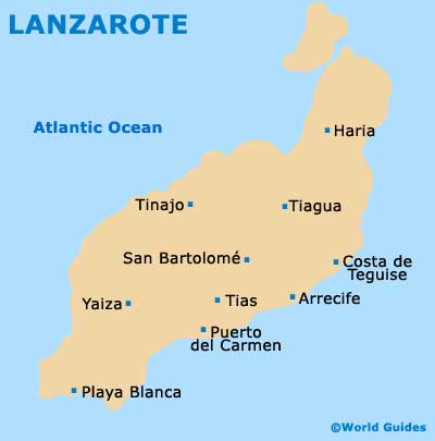
Visitors to Lanzarote will find themselves graduating towards the capital, the town of Arrecife, which is located on the eastern coast. This is a prominent port town and while lacking somewhat in architectural delights and character, particularly when compared with Costa de Teguise, Arrecife is an important transport hub and close to the airport.
Maps and Orientation of the City
Arrecife is not a difficult town to navigate and maps aren't really necessary, unless you have chosen to rent a car at the airport and decide to explore the island yourself. Alternatively, buses connect the Playa del Reducto and the town's bus station, on the north-eastern side of Arrecife. For local shopping and dining possibilities, consider the Avenida León y Castillo or the Avenida Generalisimo Franco.
The following are distance from the Lanzarote capital of Arrecife:
- Costa de Teguise - 7 km / 4 miles (ten minutes, north-east)
- Haria - 29 km / 18 miles (40 minutes, north)
- Playa Blanca - 34 km / 21 miles (45 minutes, south-west)
- Puerto del Carmen - 16 km / 10 miles (20 minutes, south-west)
- San Bartolome - 11 km / 7 miles (15 minutes, north-west)
- Tiagua - 17 km / 11 miles (25 minutes, north)
- Tias - 12 km / 7 miles (15 minutes, west)
- Tinajo - 22 km / 14 miles (30 minutes, north-west)
- Yaiza - 23 km / 14 miles (30 minutes, west)
Map of the Canary Islands

Map of Lanzarote