Bordeaux Maps and Orientation
(Bordeaux, Gironde, Aquitaine, France)
The French city of Bordeaux lies within the Aquitaine region, where it has become the capital city. With more than 200,000 inhabitants, the metropolitan area of Bordeaux is enormous and features a population in excess of one million people.
Bordeaux is located in south-western France and is in close proximity to the European Atlantic shoreline. The city itself has grown around the wide River Garonne, which now divides Bordeaux into two main regions, the left bank (west) and the right bank (east).
Maps and Orientation of the City
Central Bordeaux is based around the Place Gambetta and the river itself with the train station being located approximately 3 km / 2 miles to the south, off the Cours de la Marne, which leads to the Place de la Victoire, close to the Place de la Comédie.
Maps of Bordeaux city centre and the bus routes are available at the various tourist offices and are always a sensible investment, although it is usually fairly easy to find your way around, whether using public transport or simply by foot.
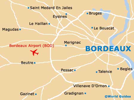
- Bègles - 8 km / 5 miles (12 minutes, south-east)
- Cenon - 11 km / 7 miles (15 minutes, north-east)
- Floirac - 19 km / 12 miles (20 minutes, east)
- Le Bouscat - 10 km / 6 miles (12 minutes, north)
- Le Haillan - 13 km / 8 miles (15 minutes, north-west)
- Lormont - 22 km / 14 miles (20 minutes, north-east)
- Mérignac - 5 km / 3 miles (9 minutes, west)
- Pessac - 6 km / 4 miles (10 minutes, south-west)
- Talence - 4 km / 2.5 miles (7 minutes, south)
Map of France

Map of Bordeaux