Lincoln Maps and Orientation
(Lincoln, Lincolnshire, England, UK)
Located on the eastern side of central
England and within the county of Lincolnshire, the city of Lincoln lies within the East midlands region where it now has a population of just over 100,000 people. Lincoln is a compact city and easy to find your way around on foot, with the High Street forming an important artery.
In approximately one hour, it is quite possible to walk from one side of Lincoln to the other, even at a fairly leisurely pace. However, it will likely take considerably longer if you intend to sightsee along the way.
Maps and Orientation of the City
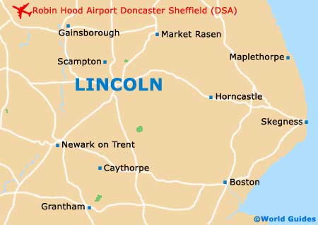
The city's cathedral is always a useful landmark and point of reference, and stands atop a prominent hill, in the very heart of Old Town Lincoln. Conveniently close by is the castle and the other main attractions.
Just under 1.5 km / 1 miles from Lincoln Cathedral is the New Town area, where both the bus and railway stations are to be found, connected by the aptly named Steep Hill. City maps are in good supply at the tourist offices (TIC) on the Castle Hill and on the Cornhill, close to the entrance of the cathedral.
- Boston - 53 km / 33 miles (55 minutes, south-east)
- Burwell - 51 km / 32 miles (50 minutes, east)
- Chapel St. Leonards - 70 km / 44 miles (one hour and ten minutes, east)
- Chesterfield - 77 km / 48 miles (one hour and 15 minutes, west)
- Cleethorpes - 64 km / 40 miles (one hour and five minutes, north-east)
- Derby - 91 km / 57 miles (one hour and 25 minutes, south-west)
- Doncaster - 67 km / 42 miles (one hour and five minutes, north-west)
- Grantham - 42 km / 26 miles (45 minutes, south)
- Grimsby - 64 km / 40 miles (one hour and five minutes, north-east)
- Horncastle - 35 km / 22 miles (35 minutes, east)
- Hull - 74 km / 46 miles (one hour and ten minutes, north)
- Humberston - 54 km / 34 miles (55 minutes, north-east)
- Ingoldmells - 67 km / 42 miles (one hour and five minutes, east)
- Leicester - 88 km / 55 miles (one hour and 25 minutes, south-west)
- Louth - 43 km / 27 miles (45 minutes, north-east)
- Mablethorpe - 69 km / 43 miles (one hour and ten minutes, east)
- Mansfield - 61 km / 38 miles (one hour, south-west)
- Newark on Trent - 30 km / 19 miles (30 minutes, south-west)
- Nottingham - 64 km / 40 miles (one hour and five minutes, south-west)
- Peterborough - 106 km / 66 miles (one hour and 35 minutes, south)
- Rotherham - 72 km / 45 miles (one hour and ten minutes, north-west)
- Scunthorpe - 43 km / 27 miles (45 minutes, north)
- Sheffield - 96 km / 60 miles (one hour and 20 minutes, west)
- Skegness - 67 km / 42 miles (one hour and five minutes, east)
- Spalding - 70 km / 44 miles (one hour and ten minutes, south)
- Stamford - 89 km / 55 miles (one hour and 20 minutes, south)
- York - 119 km / 74 miles (one hour and 45 minutes, north-west)
Map of the United Kingdom

Map of Lincolnshire
Map of Lincoln