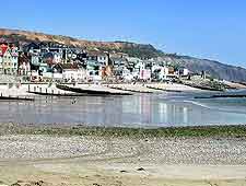
Lyme Regis Maps and Orientation
(Lyme Regis, Dorset, England, UK)
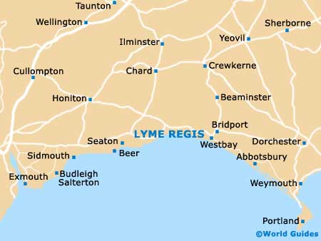
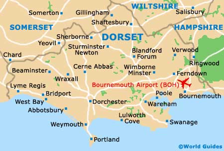
A popular town located in West Dorset, Lyme Regis lies on the south-easterly coastline of
England, next to the Devon and Dorset boundary.
Lyme Regis stands next to Lyme Bay and the English Channel, and in between Dorchester and
Exeter, which lie to the east and west respectively and are approximately 50 km / 27 miles away. The towns of Axminster, Chard, Crewkerne, Ilminster, Sidmouth, Taunton and Yeovil are also within reach of Lyme Regis and well connected by road.
Maps and Orientation of the Town
The A3052 is an important road that drops steeply into Lyme Regis, looping around and then climbing back out of the town again, after meeting the coastline at Bridge Street. For town maps, the Lyme Regis tourist information is a useful place to come and is to be found at the point where Bridge Street meets Church Street.
From here, Marine Parade is an important local thoroughway and heads in a westerly direction from the harbourfront, stopping at the Cobb Gate. The Marine Parade runs parallel to the Town Beach and is lined with useful facilities, such as gift shops and cafes.
- Abbotsbury - 35 km / 19 miles (30 minutes, south-east)
- Axminster - 10 km / 6 miles (ten minutes, north-west)
- Bath - 96 km / 60 miles (one hour and 40 minutes, north-east)
- Beer - 16 km / 10 miles (19 minutes, west)
- Bournemouth - 86 km / 54 miles (one hour and 25 minutes, east)
- Bridport - 16 km / 10 miles (18 minutes, east)
- Bristol - 109 km / 68 miles (one hour and 45 minutes, north-east)
- Chard - 19 km / 12 miles (25 minutes, north)
- Charminster - 40 km / 25 miles (45 minutes, east)
- Cheddar Gorge - 98 km / 53 miles (one hour and 35 minutes, north)
- Crewkerne - 26 km / 16 miles (30 minutes, north-east)
- Dartmouth - 107 km / 67 miles (one hour and 45 minutes, south-west)
- Dawlish - 61 km / 38 miles (one hour and ten minutes, south-west)
- Dorchester - 40 km / 25 miles (one hour, east)
- Exeter - 51 km / 32 miles (55 minutes, west)
- Exmouth - 46 km / 29 miles (50 minutes, south-west)
- Glastonbury - 64 km / 40 miles (one hour and ten minutes, north)
- Ilminster - 29 km / 18 miles (35 minutes, north)
- Isle of Wight (Cowes) - 144 km / 90 miles (two hours and 50 minutes - via ferry, north)
- Martock - 40 km / 25 miles (45 minutes, north)
- Newton Abbot - 70 km / 44 miles (one hour and 15 minutes, south-west)
- Paignton - 83 km / 52 miles (one hour and 20 minutes, south-west)
- Plymouth - 112 km / 70 miles (one hour and 45 minutes, south-west)
- Poole - 78 km / 49 miles (one hour and 15 minutes, east)
- Portsmouth - 168 km / 105 miles (two hours and 30 minutes, east)
- Salisbury - 104 km / 65 miles (one hour and 45 minutes, north-east)
- Seaton - 15 km / 8 miles (15 minutes, west)
- Sherborne - 53 km / 33 miles (one hour and five minutes, north-east)
- Sidmouth - 27 km / 17 miles (30 minutes, west)
- Somerton - 48 km / 30 miles (55 minutes, north)
- Southampton - 128 km / 80 miles (two hours, east)
- Sturminster Newton - 72 km / 45 miles (one hour and 20 minutes, north-east)
- Taunton - 45 km / 28 miles (50 minutes, north)
- Torbay - 80 km / 50 miles (one hour and 20 minutes, south-west)
- West Bay - 22 km / 12 miles (22 minutes, north)
- Weston Super Mare - 96 km / 60 miles (one hour and 40 minutes, north)
- Weymouth - 46 km / 29 miles (55 minutes, south-east)
- Yeovil - 43 km / 27 miles (50 minutes, north-east)
Map of the United Kingdom

Map of Dorset
Map of Lyme Regis