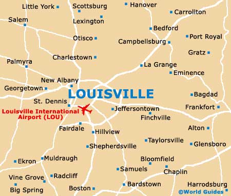
Louisville Maps and Orientation
(Louisville, Kentucky - KY, USA)
Located on the northern side of Kentucky and alongside the border with
Indiana, the city of Louisville is the state's biggest, although
Frankfort is actually the capital. However, Louisville does serve as the administrative center for Jefferson County.
The Ohio River bounds the northern side of the city, being spanned by a series of bridges, such as the Dr. Martin Luther King Jr. Expressway (Interstate I-65). Close by is the Clark Memorial Bridge (US-31), which connects the Central Business District with Riverside Drive and the Falls of the Ohio State Park.
In the early days of Louisville, the river brought the city great wealth, being used for shipping as the city gradually expanded. Today, the riverside has never been more popular with locals, with the Waterfront Park on River Road being a major recreational spot. The park features play areas, fountains, open grass, skyline vistas and summer concerts, as well as a popular Riverwalk pathway leading to Shawnee Park. Close by, the Slugger Field baseball park is a useful point of reference.
Maps and Orientation of the City
The neighborhood known locally as Old Louisville resides on the southerly side of the downtown district and is certainly a highlight for sightseers looking to get to know the city a little better. Standing next to Magnolia Avenue, St. James Court is a notable highlight here, along with a cottage that was once called home by the famous inventor Thomas Eddison (of light bulb fame).
Maps of the city can be found at the Visitor Center on South 4th Street (next to the Hyatt Regency Hotel), at the Public Library on York Street, and from bookstores close to the University of Louisville campus.
- Bardstown - 41 miles / 66 km (one hour and five minutes, south)
- Bloomington - 105 miles / 169 km (two hours and 30 minutes, northwest)
- Campbellsburg - 38 miles / 61 km (one hour, northeast)
- Charlestown - 19 miles / 31 km (35 minutes, north)
- Cincinnati - 99 miles / 159 km (two hours and 25 minutes, northeast)
- Fairdale - 14 miles / 23 km (25 minutes, south)
- Finchville - 33 miles / 53 km (50 minutes, east)
- Georgetown - 72 miles / 116 km (one hour and 45 minutes, east)
- Hillview - 16 miles / 26 km (25 minutes, south)
- Indianapolis - 115 miles / 185 km (two hours and 45 minutes, north)
- Jeffersontown - 15 miles / 24 km (25 minutes, east)
- La Grange - 25 miles / 40 km (40 minutes, northeast)
- Lexington - 75 miles / 121 km (one hour and 40 minutes, east)
- New Albany - 8 miles / 13 km (15 minutes, northwest)
- Radcliff - 42 miles / 68 km (one hour and five minutes, south)
- Scottsburg - 36 miles / 58 km (one hour, north)
- Shepherdsville - 21 miles / 34 km (35 minutes, south)
- St. Dennis - 8 miles / 13 km (15 minutes, southwest)
Map of the United States

Map of Kentucky

Map of Louisville