Norwich Maps and Orientation
(Norwich, Norfolk, England, UK)
As the county town of Norfolk, Norwich is a city of some size and stature, with a population soon expected to top 400,000 residents. In the 11th century, Norwich was actually England's second-biggest city, after only
London, although that claim to fame was fairly short lived.
Suburban Norwich extends considerably further than the actual boundary of the city and encompasses a number of towns and parishes, such as Costessey, Hellesdon and Thorpe St. Andrew. Further city suburbs include the small villages of both Old Catton and Sprowston, the latter of which lies alongside Heartsease and Mousehold Heath.
Maps and Orientation of the City
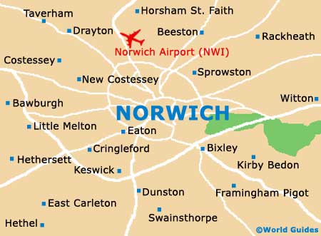
Central Norwich is dominated by its castle, with the local tourist office being located just two blocks to the west and a good place to pick up some free maps. Next to the castle is an area of great medieval interest, which comes complete with Anglican cathedral, city walls, a myriad of lanes and alleyways, and in excess of 30 different parish churches, many of which are close to the meandering River Wensum.
In the very heart of Norwich is the bustling market, which is especially historic and always a good point of reference. The following destinations are within reach of Norwich, by road or rail:
- Bury St. Edmunds - 72 km / 45 miles (one hour and five minutes, south-west)
- Cambridge - 104 km / 65 miles (one hour and 30 minutes, south-west)
- Clacton on Sea - 114 km / 71 miles (one hour and 40 minutes, south)
- Colchester - 96 km / 60 miles (one hour and 30 minutes, south)
- Cromer - 37 km / 23 miles (45 minutes, north)
- Felixstowe - 94 km / 59 miles (one hour and 25 minutes, south)
- Great Yarmouth - 34 km / 21 miles (35 minutes, east)
- Hemsby - 34 km / 21 miles (35 minutes, east)
- Ipswich - 72 km / 45 miles (one hour and 15 minutes, south)
- Kessingland - 43 km / 27 miles (50 minutes, south-east)
- Leicester - 206 km / 128 miles (two hours and 45 minutes, west)
- London - 186 km / 116 miles (two hours and 30 minutes, south-west)
- Lowestoft - 50 km / 31 miles (50 minutes, south-east)
- Luton - 163 km / 102 miles (two hours and 20 minutes, south-west)
- Newmarket - 83 km / 52 miles (one hour and 20 minutes, south-west)
- Peterborough - 131 km / 82 miles (one hour and 55 minutes, west)
- Sheringham - 43 km / 27 miles (50 minutes, north)
- Southwold - 50 km / 31 miles (50 minutes, south-east)
- Stevenage - 146 km / 91 miles (two hours, south-west)
- Stowmarket - 59 km / 37 miles (one hour, south)
- Thetford - 99 km / 62 miles (one hour and 30 minutes, south-west)
Map of the United Kingdom

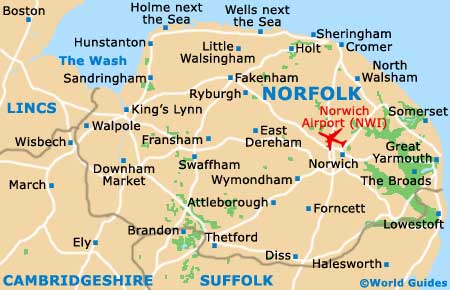
Map of Norfolk
Map of Norwich