Newquay Maps and Orientation
(Newquay, Cornwall, England, UK)
Lying on Cornwall's northern Atlantic coast, the town of Newquay is a major holiday destination, located directly north of
Truro and close to many other prominent coastal areas. Newquay has expanded greatly in recent years and is how home to a population of around 19,000 people, although during the busy summer season, this can regularly exceed 100,000. The town and can be found in the borough of Restormel, in south-west
England.
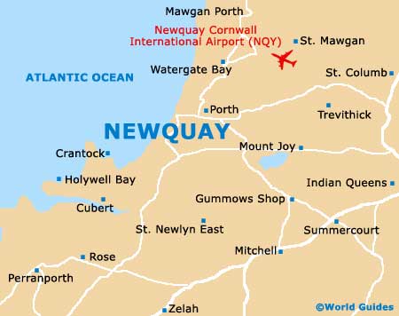
Maps and Orientation of the Town
Being such a popular tourist hotspot, Newquay is easy to reach and is located off the A30, which heads in a north easterly direction and links Launceston, the Dartmoor National Park,
Exeter and the A303. Also nearby Newquay, other major roads include the A30, A38, the A39, the A390 and the A391.
The western side of Newquay is edged by the Gannel River, and on its eastern side by the beautiful Porth Valley. Originally a small and rather charming fishing village, Newquay is protected from weather extremes by a prominent, curving headland. In total, Newquay contains ten main sandy beaches and plenty of surfing opportunities.
Nearby towns and villages close to Newquay are listed below, together with distances, journey times and directions.
- Bodmin - 34 km / 21 miles (50 minutes, east)
- Camborne - 34 km / 21 miles (52 minutes, south-west)
- Crantock - 6 km / 4 miles (15 minutes, south-west)
- Falmouth - 42 km / 26 miles (50 minutes, south)
- Holywell Bay - 10 km / 6 miles (22 minutes, south-west)
- Kestle Mill - 6 km / 4 miles (13 minutes, south-east)
- Mevagissey - 35 km / 22 miles (45 minutes, south-west)
- Porth - 3 km / 2 miles (6 minutes, north-east)
- Redruth - 26 km / 16 miles (39 minutes, south-west)
- St. Austell - 26 km / 16 miles (32 minutes, south-east)
- St. Newlyn East - 8 km / 5 miles (13 minutes, south)
- Truro - 26 km / 16 miles (27 minutes, south)
- Wadebridge - 26 km / 16 miles (27 minutes, north-east)
- Watergate Bay - 6 km / 4 miles (8 minutes, north-east)
Map of the United Kingdom

Map of Cornwall

Map of Newquay