Kyrenia Maps and Orientation
(Kyrenia, Cyprus)
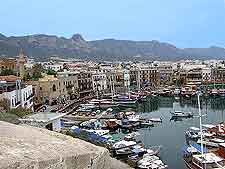
Located on the northerly coastline of North Turkey, the island's Turkish sector, Kyrenia is a popular town boasting an especially historic harbour. The conflict suffered by Kyrenia during the 1974 Turkish occupation has long gone and this charming seaside resort is currently enjoying a resurgence of popularity, with holiday makers generally arriving here from the UK,
Germany and also
Turkey.
Kyrenia is comprised of mainly Turkish Cypriots these days, as well as some settlers who have arrived from Turkey. Therefore, there is an undeniable Turkish vibe present here, which is very much reflected in its cuisine and local shops.
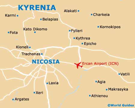
Maps and Orientation of the Town
Kyrenia is a spreading town, although tourists will find that the centrally located Old Town district is relatively compact and the best place for sightseeing. Minibuses tend to arrive on the Ecevit Caddesi and close to Belediye Meydani (main square), on the southerly side of the Old Harbour. Nearby, the North Cyprus Tourism Organisation (NCTO) on the Girne Limani is a good place to find maps.
On the western side of the Belediye Meydani, the Ziya Rizki Caddesi is a good place to shop in Kyrenia. Directly to the south-east, the Mustafa Cagatay Caddesi runs to the New Harbour and its Turkish ferries.
- Ayia Napa (Agia Napa / Aya Napa) - far south-east
- Ayios Amvrosios - east
- Bellapais - south-east
- Camlibel - west
- Famagusta (Ammóchostos / Gazimagusa) - far south-east
- Guzelyali - west
- Halevga - south-east
- Karpasha - west
- Kato Dhikomo - south
- Larnaca (Larnaka) - far south-east
- Limassol (Lemesos / Limasol / Leymosun) - far south-west
- Liveras - west
- Myrtou - west
- Nicosia (Lefkosia) - south
- Paphos (Pafos / Paphus) - far south-west
- Peristonera - south-west
- Skilloura - south-west
- Typimeni - east
- Ulukisia - south-east
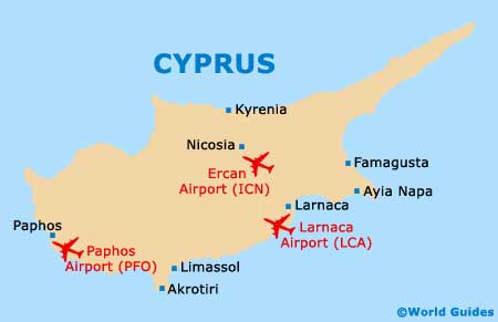
Map of Cyprus
Map of Kyrenia