Pierre Maps and Orientation
(Pierre, South Dakota - SD, USA)
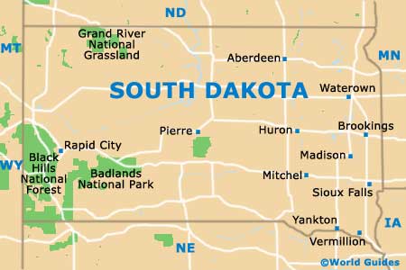
The state of South Dakota is located on the northern side of North America, directly south of
North Dakota, in between
Minnesota and
Wyoming.
Pierre serves as the state capital, whilst also being the county seat for Hughes County. However, the city of Pierre is relatively small for a state capital, with its population of 15,000 people, and is actually currently only the eighth-largest city in the state of South Dakota, after Sioux Falls, Rapid City, Aberdeen, Brookings, Watertown, Mitchell and Yankton.
The city is based on a series of rough river bluffs, being both founded and incorporated in the early 1880s. Pierre has grown up around the Missouri River and is just a few kilometers from Lake Oahe, one of the world's biggest artificial lakes.
Maps and Orientation of the City
Many attractions reside around downtown Pierre, such as the South Dakota Capitol Building, the Saints Peter and Paul Catholic Church, Steamboat Park and the State 1-2-3 Theater. Detailed maps should clearly annotate all of the local landmarks and more.
When planning your way around Pierre, La Framboise Island is a useful point of reference on all city maps, residing in the center of the Missouri River. This island is an important nature spot, being covered in wooded areas and wild meadows, and found directly opposite both Griffin Park and the Marine Recreational Area.
- Aberdeen - northeast
- Belle Fourche - west
- Brookings - east
- Chamberlain - southeast
- Fort Pierre - southwest
- Gettysburg - north
- Huron - east
- Lake Sharpe - east
- Mitchell - southeast
- Rapid City - west
- Selby - north
- Sioux Falls - southeast
- Sturgis - west
- Watertown - east
- Winner - south
Map of USA
Map of South Dakota
Map of Pierre
