Nassau Maps and Orientation
(Nassau / Paradise Island, New Providence, Bahamas)
Paradise Island lies just off the north coast of New Providence Island, in northern / central
Bahamas. It is just minutes from the capital city of Nassau and is a small island on maps, roughly 6 km / 4 miles across and only a maximum of 800 metres / 2,625 feet deep. The island is connected to the mainland by two bridges.
The best beaches of Paradise Island - the main draw - are in the north of the island, facing the Atlantic Ocean. Hotels and shops back the Cabbage and Paradise beaches, while the docks, marinas and bridges are on the south side. The Paradise Island Golf Course is in the east of the island, the lushest part, and off to the west are more remote beaches where the island narrows to a point. Paradise Island Drive links up the golf course.
Maps and Orientation of the Area / Resorts
The Atlantis Bridge leads from Nassau into the island's main road and reaches a central roundabout, a significant landmark here. To the north and west of this point are the big hotels Paradise Island is famed for. Immediately west of the roundabout on maps is Paradise Lake, while south is the Dolphin Centre and the dock. Hotels here are almost like mini cities, having their own stretch of beach and shopping and entertainment.
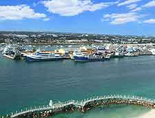
In Nassau, the historic downtown area is approximately ten blocks in length and just four blocks in width, and faces north towards the harbourfront. To the south, the elevated Prospect Ridge and Blue Hill Heights provide elevated vantage points, and between these ridges is the main residential area. Bay Street forms the main east to west thoroughfare in Nassau, connecting the Atlantis Bridge and ultimately Paradise Island.
Useful distances from Paradise Island:
- Adelaide Village - 25 km / 15 miles (30 minutes, south-west)
- Blue Lagoon Island (boat) - 5 km / 3 miles (30 minutes, north-east)
- Cable beach Golf Course - 4 km / 3 miles (ten minutes, south-west)
- Lynden Pindling International Airport - 20 km / 12 miles (30 minutes, south-west)
- Nassau - 5 km / 3 miles (15 minutes, south)
Map of the Bahamas

Map of New Providence Island
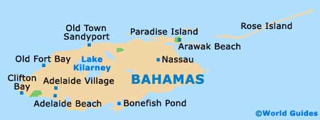
Map of Nassau / Paradise Island

