Palma Nova Maps and Orientation
(Palma Nova, Mallorca, Balearic Islands, Spain)
Detailed maps of
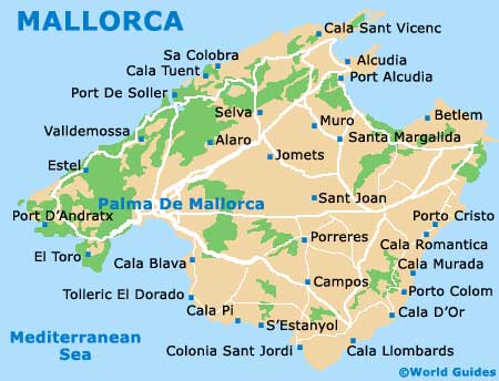
Mallorca reveal that Palma Nova is essentially a suburb of the city of
Palma de Mallorca, and that it lies just a few miles south of the capital along the Ma-1 motorway. Driving to Palma city centre just takes a few minutes, so long as traffic doesn't enter into the equation.
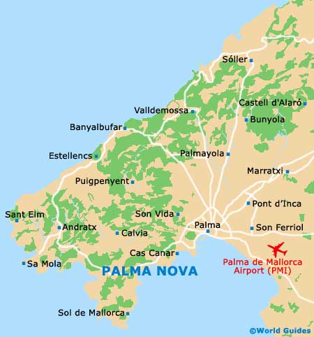
On the way from Palma to Palma Nova, drivers first pass through Bellver Park, which lies on the outskirts and marks the beginning of the suburbs. From here, it's on to Sant Agusti, Cas Canar and Portals Nous, before finally arriving in Palma Nova. Each of these communities is nothing more than a small dot on the map.
Maps and Orientation of the Resort
Just a short distance to the south is Magaluf, an even livelier community with more facilities available than in Palma Nova. English-language maps are easy to find here and in Palma Nova, as these two communities specifically attract British package tourists. The easiest way to acquire a map is simply to ask the front desk of your hotel. They will either have maps on hand or will be able to point you to the nearest store where they can be purchased.
You will also want to consider picking up a map for driving purposes. Getting around Palma Nova without much direction is no problem, but anyone planning day trips into the countryside will need some help with regards to navigating.
- Alcúdia - 67 km / 42 miles (50 minutes, north-east)
- Castell d'Alaró - 42 km / 26 miles (35 minutes, north-east)
- Coves del Drac - 80 km / 50 miles (one hour and 15 minutes, east)
- Fornalutx - 42 km / 26 miles (35 minutes, north-east)
- Magaluf - 3 km / 2 miles (five minutes, south)
- Manacor - 65 km / 41 miles (one hour, east)
- Palma de Mallorca - 14 km / 9 miles (15 minutes, north-east)
- Parc Natural de s'Albufera - 70 km / 44 miles (one hour, north-east)
- Port d'Andratx - 20 km / 12 miles (20 minutes, west)
- Santa Ponca - 8 km / 5 miles (12 minutes, south-west)
- Son Servera - 81 km / 50 miles (one hour and 20 minutes, east)
Map of Spain

Map of Mallorca
Map of Palma Nova
More information about
Mallorca maps
