Mallorca Maps and Orientation
(Mallorca / Majorca, Balearic Islands, Spain)
Mallorca, also frequently referred to as Majorca, is sited within the Mediterranean Sea and the biggest of the Balearic Islands, with other significant Balearics in terms of size and popularity being Formentera,
Ibiza and
Menorca.
When it comes to beaches and resorts on Mallorca, holiday makers will find that the best beaches tend to be situated on the northern and eastern shore, with many sizeable tourist resorts being based here. The north-westerly coastline is home to the mountain range named the Serra de Tramuntana, being less developed and packed with forests, villages and less commercial beaches.
Maps and Orientation of the City
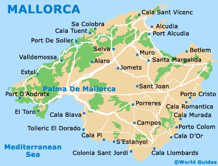
Palma de Mallorca resides on the southern side of the island, where it serves as the capital city. All of the areas beyond Palma are described as being 'part forana', which basically translates as the 'part outside'. Those planning to drive around Mallorca are advised to purchase some good, up-to-date maps. The following distances and directions are calculated from Palma:
- Algaida - 25 km / 16 miles (30 minutes, east)
- Andratx - 28 km / 17 miles (35 minutes, west)
- Binissalem - 27 km / 17 miles (30 minutes, north-east)
- Bunyola - 20 km / 12 miles (25 minutes, north)
- Calvia - 19 km / 12 miles (25 minutes, west)
- Fornalutx - 35 km / 22 miles (45 minutes, north)
- Inca - 34 km / 21 miles (45 minutes, north-east)
- Llucmajor - 26 km / 16 miles (30 minutes, south-east)
- Manacor - 52 km / 32 miles (one hour, east)
- Marratxi - 17 km / 11 miles (20 minutes, north-east)
- Pollenca - 56 km / 35 miles (one hour and 15 minutes, north-east)
- Sa Pobla - 46 km / 29 miles (50 minutes, north-east)
- Santa Margalida - 57 km / 35 miles (one hour and five minutes, north-east)
- Soller - 29 km / 18 miles (35 minutes, north)
Map of Spain

Map of Mallorca