Venice Maps and Orientation
(Venice, Veneto, Italy)
Located on the eastern side of North Italy, Venice (Venezia in Italian) stands within the Veneto region, where it is the capital city. Considering that Venice has so many canals and bridges, it is understandable that many a tourists has found navigating this epic watery city a little puzzling at times.
Do note that there are actually only four bridges that cross over the Grand Canal. These bridges are named the Ponte dell' Accademia, the Ponte di Rialto and the Ponte dei Scalzi. The fourth of these is the rather more contemporary Ponte della Costituzione, which connects the Piazzale Roma with the railway station. However, many tourists looking to cross Venice's famous Grand Canal simply opt for a ferry trip or gondola ride.
Maps and Orientation of the City
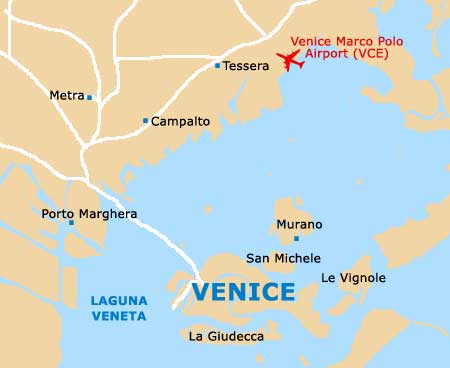
To the north and south, the Laguna Veneta comprises a series of small islands, such as Burano, Murano and Torcello. Directly east is the Lido di Venezia, which heads in a southerly direction for some 10 km / 6 miles.
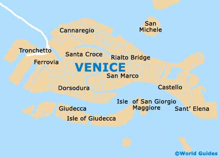
Venice is relatively organised in structure, being divided into a total of six different districts, known to the locals as 'sestieri'. These districts are named Cannaregio, Castello, Dorsoduro, San Marco, San Polo and Santa Croce. For maps and general tourism advice, consider paying a visit to the various Azienda di Promozione Turistica offices located around the city.
The following routes include ferries, while road tolls may also be applicable:
- Bologna - 159 km / 99 miles (two hours and 15 minutes, south-west)
- Camponogara - 32 km / 20 miles (one hour, south-west)
- Carbonera - 43 km / 27 miles (one hour and 15 minutes, north)
- Marcon - 28 km / 17 miles (55 minutes, north)
- Martellago - 26 km / 16 miles (55 minutes, north-west)
- Mira - 24 km / 15 miles (50 minutes, west)
- Mirano - 27 km / 17 miles (55 minutes, west)
- Mogliano Veneto - 23 km / 14 miles (50 minutes, north-west)
- Quarto d'Altino - 33 km / 21 miles (one hour, north)
- Roncade - 38 km / 24 miles (one hour and ten minutes, north)
- Salzano - 30 km / 19 miles (one hour, north-west)
- San Dona di Piave - 43 km / 27 miles (one hour and 15 minutes, north-east)
- Scorze - 32 km / 20 miles (one hour, north-west)
- Trebaseleghe - 38 km / 24 miles (one hour and ten minutes, north-west)
- Treviso - 47 km / 29 miles (one hour and 20 minutes, north)
Map of Italy

Map of Venice