Nottingham Maps and Orientation
(Nottingham, Nottinghamshire, England, UK)
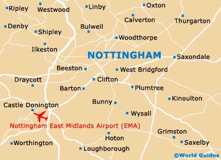
A large and densely populated city in the county of Nottinghamshire, Nottingham is an appealing destination and it is worth making the time to explore this area. Much of Nottingham is surrounded by A roads, with the A6515 (Valley Road) and the A52 (Clifton Boulevard) being especially notable, lying on the western side of the city. Further west you will find the M1 motorway, which heads north - south and passes nearby Ilkestone and Stapleford along the way.
Around the city itself, important landmarks include the University of Nottingham, located on the south-western outskirts, alongside Wollaton Park and just a short distance from Beeston. Sited in the south-eastern suburbs, Colwick Country Park features a series of lakes and covers more than 250 acres / 100 hectares.
Maps and Orientation of the City
Noteworthy thoroughfares in the centre of Nottingham include Maid Marian Way, Wollaton Street, Ilkeston Road, the Castle Boulevard, Queens Drive and the London Road, amongst others.
Nottingham is close to a number of particularly prominent UK cities and towns. The distance, journey time and direction are shown below.
- Birmingham - 82 km / 51 miles (one hour, south-west)
- Chesterfield - 45 km / 28 miles (40 minutes, north-west)
- Coventry - 80 km / 50 miles (one hour, south-west)
- Derby - 26 km / 16 miles (25 minutes, west)
- Leicester - 43 km / 27 miles (40 minutes, south)
- Lincoln - 61 km / 38 miles (50 minutes, north-east)
- London - 201 km / 125 miles (two hours and 20 minutes, south-east)
- Loughborough - 31 km / 19 miles (30 minutes, south)
- Peterborough - 92 km / 57 miles (one hour and 15 minutes, south-east)
- Sheffield - 71 km / 44 miles (55 minutes, north)
Map of the United Kingdom

Map of Nottinghamshire

Map of Nottingham