Torbay Maps and Orientation
(Brixham / Paignton / Torquay - Torbay, Devon, England, UK)
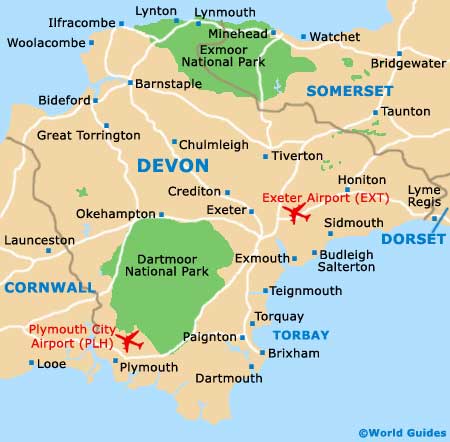
Located on the south-westerly coastline of
England, Torbay is a large are spreading region, fronting a natural harbour and lying alongside the westerly end of Lyme Bay. Torbay is to be found part-way between north
Exeter and
Plymouth, and comprises the three towns of Brixham, Paignton and Torquay.
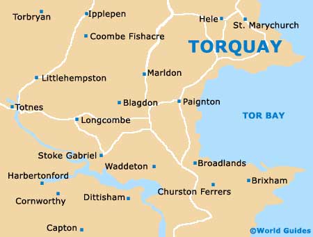
Torquay stands on the northerly side of Torbay, while Paignton resides in the very centre and Brixham to the south. These three towns have been closely connected in recent years and the overall region has further expanded to now include the villages of Churston, Cockington, Ferrers, Galmpton, Marldon and St. Marychurch.
Maps and Orientation of the Region
Most holiday makers in Torbay choose to hop between the towns, generally using the A3022 (Torquay Road / Totnes Road / Brixham Road) to reach their chosen destination. The distance between Paignton and Torquay is just over 5 km / 3 miles, while from Torquay, Brixham is a little under 14 km / 9 miles to the south and next to both Churston Ferrers and Lupton.
Many locals consider Paignton to be a suburb of Torquay and this town has grown to become central to the region's tourism industry, even though it is much smaller. Maps of Torbay and Devon are available from Torquay, at the Tourist Information Centre (TIC) on Vaughan Parade. This TIC is open throughout the year as follows: June to September, Monday to Saturday - 09:30 to 18:00, Sunday - 10:00 to 18:00; October to May, Monday to Saturday - 09:30 to 17:00.
- Buckfastleigh - 22 km / 14 miles (30 minutes, west)
- Cott - 14 km / 9 miles (20 minutes, west)
- Cullompton - 56 km / 35 miles (one hour and five minutes, north)
- Dawlish - 26 km / 16 miles (30 minutes, north)
- Dartmouth - 29 km / 18 miles (35 minutes, south)
- Dorchester - 120 km / 75 miles (one hour and 45 minutes, north-east)
- Exeter - 38 km / 24 miles (40 minutes, north)
- Exmouth - 50 km / 31 miles (50 minutes, north-east)
- Kingsbridge - 34 km / 21 miles (40 minutes, south-west)
- Kingswear - 14 km / 9 miles (20 minutes, south)
- Launceston - 98 km / 61 miles (one hour and 25 minutes, north-west)
- Lyme Regis - 85 km / 53 miles (one hour and 15 minutes, north-east)
- Lynton and Lynmouth - 131 km / 82 miles (one hour and 55 minutes, north)
- Newton Abbot - 14 km / 9 miles (20 minutes, north-west)
- Okehampton - 69 km / 43 miles (one hour and ten minutes, north-west)
- Plymouth - 48 km / 30 miles (50 minutes, west)
- Salcombe - 42 km / 26 miles (45 minutes, south-west)
- Seaton - 67 km / 42 miles (one hour and ten minutes, north-east)
- Sidmouth - 54 km / 34 miles (one hour, north-east)
- Stoke in Teignhead - 13 km / 8 miles (18 minutes, north)
- Taunton - 83 km / 52 miles (one hour and 15 minutes, north-east)
- Tavistock - 58 km / 36 miles (one hour and five minutes, west)
- Teignmouth - 19 km / 12 miles (25 minutes, north)
- Torpoint - 54 km / 34 miles (one hour, west)
- Totnes - 11 km / 7 miles (15 minutes, west)
- Weymouth - 126 km / 79 miles (one hour and 50 minutes, east)
Map of the United Kingdom

Map of Devon
Map of Torbay