Split Maps and Orientation
(Split, Central Dalmatia, Croatia)
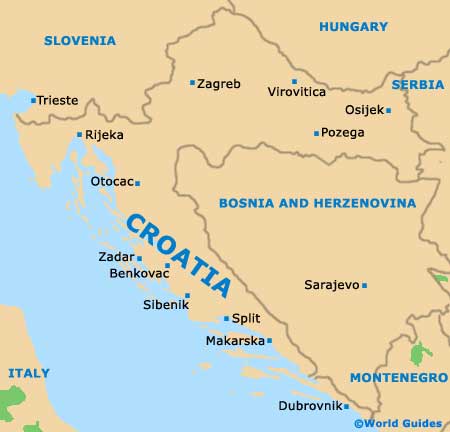
Split is located on the Central Dalmatia coast, between
Dubrovnik (further south) and
Zadar. The city is a fair way south of the bulk of
Croatia and is one of the country's major gateways, having an airport as well as good rail and bus access, together with a sizeable port.
Maps are needed for getting about as there is an Old Town and a New Town, along with a harbour and port area that stretches along the shore a fair way. The centre in its entirety is about 5 km / 3 miles across and sits on a small peninsula, although from the point of view of tourists, the action is all up behind the harbour in a compact area.
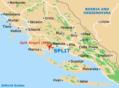
Maps and Orientation of the City
The ferry port, to the south and east of the harbour proper and Old Town, forms the busiest part of Split, being just down from Riva promenade - the main thoroughfare. Further back again is the rambling
Diocletian's Palace, showing as behind the harbour on Split maps.
The Diocletian Palace functions as the historic core and is bounded by city walls and major streets. You will also need maps to get around this ancient centre, as it consists of a network of close-knit alleys. If you haven't previously picked up maps online, then look to the principal tourist information office, on the Peristyle (square) of Diocletian's Palace.
- Brac Island (includes ferry) - 34 km / 21 miles (one hour, south)
- Brela - 51 km / 32 miles (one hour, south-east)
- Dubrovnik - 260 km / 162 miles (four hours and ten minutes, south-east)
- Dugi Rat - 20 km / 12 miles (25 minutes, south-east)
- Kastela - 18 km / 11 miles (25 minutes, north-west)
- Klis - 13 km / 8 miles (15 minutes, north-east)
- Makarska - 62 km / 39 miles (one hour and 15 minutes, south-east)
- Narona - 5 km / 3 miles (ten minutes, north-east)
- Omis - 26 km / 16 miles (30 minutes, south-east)
- Plitvice National Park - 160 km / 100 miles (one hour and 50 minutes, north-west)
- Podstrana - 11 km / 7 miles (15 minutes, south-east)
- Rijeka - 360 km / 224 miles (five hours, north-west)
- Sarajevo (Bosnia and Herzegovina) - 170 km / 105 miles (two hours, east)
- Seget - 32 km / 20 miles (40 minutes, west)
- Sibenik - 70 km / 43 miles (one hour and 20 minutes, north-west)
- Solin (Salona) - 7 km / 4 miles (ten minutes, north-east)
- Split Airport - 23 km / 15 miles (25 minutes, west)
- Trogir - 30 km / 19 miles (35 minutes, west)
- Zadar - 150 km / 93 miles (one hour and 50 minutes, north-west)
- Zagreb - 408 km / 254 miles (four hours, north)
Map of Croatia
Map of Split