Byron Bay Maps and Orientation
(Byron Bay, New South Wales - NSW, Australia)
Located within New South Wales (NSW), the coastal town of Byron Bay is to be found on the state's far North Coast, close to the border of Queensland and part-way between Grafton and the twin towns of Tweed Heads and Coolangatta.
Byron Bay may be situated in New South Wales, the same state as the popular tourist city of
Sydney, but if you are planning an excursion to see the famous
Sydney Opera House or
Harbour Bridge, then be prepared to travel some 800 km / 500 miles to the south. In fact,
Brisbane, in Queensland (QLD), is considerably closer and by car can easily be reached in well under three hours.
Maps and Orientation of the City
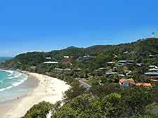
Close by, Cape Byron serves as the most easterly point on the whole of the Australian mainland, and as such, has become a leading attraction in its own right. Those with their own set of wheels will discover many enticing destinations within easy driving distance of Byron Bay, with maps being a must for any self-navigator. Excursions to the neighbouring Gold Coast are particularly popular, and these beaches are around an hour away by car.
Other notable destinations in this part of
Australia include the following selection:
- Ballina - 38 km / 24 miles (45 minutes, south)
- Bangalow - 13 km / 8 miles (15 minutes, west)
- Beenleigh - 131 km / 81 miles (two hours, north)
- Boardwater National Park - 55 km / 34 miles (one hour and 15 minutes, south)
- Brisbane - 170 km / 106 miles (two hours and 25 minutes, north)
- Brunswick Heads - 18 km / 11 miles (20 minutes, north)
- Caloundra - 260 km / 162 miles (three hours and 40 minutes, north)
- Coffs Harbour - 241 km / 150 miles (three hours and 30 minutes, south)
- Coorabell - 15 km / 9 miles (25 minutes, west)
- Grafton - 166 km / 103 miles (two hours and 20 minutes, south)
- Lismore - 45 km / 28 miles (50 minutes, south-west)
- Maroochydore - 273 km / 170 miles (three hours and 45 minutes, north)
- Mullumbimby - 30 km / 19 miles (25 minutes, north-west)
- Nambour - 270 km / 168 miles (three hours and 40 minutes, north)
- Nightcap National Park - 75 km / 47 miles (one hour and 40 minutes, west)
- Nimbin - 75 km / 47 miles (one hour and 30 minutes, west)
- Redcliffe - 199 km / 124 miles (two hours and 55 minutes, north)
- Toowoomba - 268 km / 167 miles (three hours and 40 minutes, north-west)
- Tweed Heads - 65 km / 40 miles (one hour and 20 minutes, north)
- Washpool National Park - 250 km / 155 miles (four hours, south-west)
- Whian Whian State Conservation Area - 40 km / 25 miles (one hour, west)
Map of Australia

Map of New South Wales
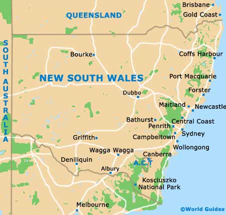
Map of Byron Bay

