Surabaya Maps and Orientation
(Surabaya, East Java, Indonesia)
A major Indonesian city located on the north-easterly coastline of East Java, Surabaya serves as the proud provincial capital and lies alongside the Madura Strait, next to the Mas River. With a population now topping three million people, Surabaya is a leading and spreading city, and has actually become the second biggest in the whole of Indonesia.
In recent years, Surabaya has grown at quite a pace and its economy is currently booming, thanks in no small part to its important port, which remains amongst the busiest that Indonesia has to offer. The city also remains a prominent commercial hub, being home to many modern high-rise offices in its Central Business District (CBD).
Maps and Orientation of the City
Central Surabaya is very much based around the Jalan Pemuda, which heads in a westerly direction from both the Plaza Surabaya and the Gubeng railway station. The Jalan Pemuda connects to the Jalan Basuki Rahmat, which serves as a further commercial street and is home to the Tunjungan Plaza, where a number of bookstores prove to be a good source of East Java maps.
The historical part of Surabaya stands around the Red Bridge (Jembatan Merah), with the Kota railway station being sited just a short distance to the north. The Purabaya bus terminal lies on the southerly outskirts of Surabaya.
- Gemarang - 130 km / 81 miles (two hours and 30 minutes, west)
- Jombang - 76 km / 47 miles (one hour and 30 minutes, south-west)
- Krucil - 160 km / 99 miles (two hours and 50 minutes, south-east)
- Lawang - 70 km / 43 miles (one hour and 20 minutes, south)
- Malang - 90 km / 56 miles (one hour and 40 minutes, south)
- Madura Island - 6 km / 4 miles (15 minutes, north)
- Plandaan - 75 km / 47 miles (one hour and 30 minutes, south-west)
- Rembang - 200 km / 124 miles (three hours and 45 minutes, north-west)
- Semarang - 325 km / 202 miles (six hours, west)
- Senduro - 143 km / 89 miles (two hours and 45 minutes, south-east)
- Solo (Surakarta) - 265 km / 165 miles (five hours, south-west)
- Sumbermanjing - 140 km / 87 miles (two hours and 45 minutes, south)
- Tempurejo - 202 km / 126 miles (three hours and 45 minutes, south-east)
- Trowulan - 60 km / 37 miles (one hour and ten minutes, south-west)
- Wonosalam - 72 km / 45 miles (one hour and 30 minutes, south-west)
- Yogyakarta - 330 km / 205 miles (six hours and 30 minutes, south-west)
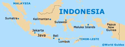
Map of Indonesia
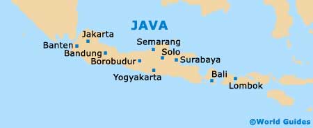
Map of Java
Map of Surabaya

