Key West Maps and Orientation
(Key West, Florida - FL, USA)
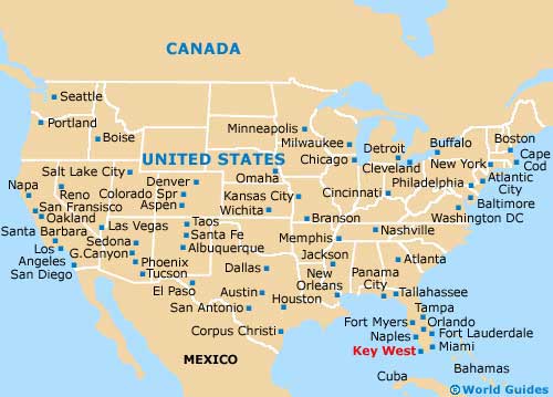
Situated within the southerly Straits of Florida, the lengthy island of Key West resides at the far southern side of the famous Florida Keys. This small city is connected to the mainland state by the Overseas Highway (A1A), which links Big Pine Key, Marathon, Islamorada and Key Largo, before reaching the Southern Glades.
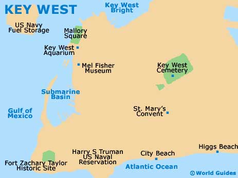
Although Key West is divided into a number of notable districts, the Old Town is where most tourists will find themselves spending time, with plenty of hotels, attractions, eateries, bars and shops being located here. The New Town tends to be where local businesses base themselves, being accompanied by a series of residential neighborhoods.
Getting around the center of Key West is really best done on foot, provided that you are not in a rush to hop between attractions and beaches. Maps can prove handy, although the gridwork of streets is really very organized and simple to navigate.
Maps and Orientation of the City
The northern shore is bounded by the North Roosevelt Boulevard (US-1), while the southern shore is partially lined by the South Roosevelt Boulevard, which passes by Key West's international airport and various hotels, such as the Best Western and the Hilton Grand Key Resort. The popular Smathers Beach also resides off the South Roosevelt Boulevard.
Another beach of great note is to be found within the Fort Zachary Taylor Historic State Park, on the far western side of the island. Further west and just a relatively short boat trip away is the secluded Key West National Wildlife Refuge, which makes for an interesting day out.
The Fort
- Big Pine Key - 30 miles / 48 km (50 minutes, east)
- Biscayne National Park - 135 miles / 217 km (three hours and 30 minutes, northeast)
- Cudjoe Key - 21 miles / 34 km (35 minutes, east)
- Duck Key - 61 miles / 98 km (one hour and 30 minutes, east)
- Everglades National Park - 170 miles / 274 km (four hours and 20 minutes, northeast)
- Fort Lauderdale - 190 miles / 306 km (four hours and 30 minutes, northeast)
- Homestead - 128 miles / 206 km (three hours and 15 minutes, northeast)
- Islamorada - 80 miles / 129 km (two hours, northeast)
- Key Colony Beach - 53 miles / 85 km (one hour and 20 minutes, east)
- Key Largo - 98 miles / 158 km ( two hours and 25 minutes, northeast)
- Layton - 67 miles / 108 km (one hour and 30 minutes, east)
- Marathon - 48 miles / 77 km (one hour and ten minutes, east)
- Miami - 160 miles / 257 km (four hours, northeast)
- No Name Key - 34 miles / 55 km (55 minutes, east)
- Princeton - 134 miles / 216 km (three hours and 30 minutes, northeast)
- Tavernier - 90 miles / 145 km (two hours and 15 minutes, northeast)
Map of the United States
Map of Florida

Map of Key West