Jacksonville Maps and Orientation
(Jacksonville, Florida - FL, USA)
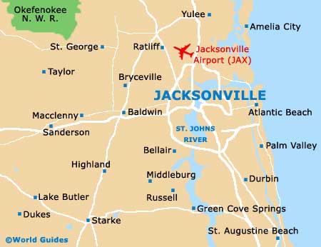
Located on the far northeastern side of Florida, the city of Jacksonville lies within the county of Duval, where it is the county seat.
Jacksonville is surrounded in most directions by national parks and reserves, including the Timucuan Ecological Historic Preserve, the Little Talbot Island State Park and the Pumpkin Hill Creek Preserve State Park, all of which are to be found to the northeast. The Four Creeks State Forest is sited to the northwest, while the Cary State Forest is to the west and the Jennings State Forest to the southwest. Head southwards and you will soon reach the Bayard Conservation Area.
Interstate I-95 is a prominent thoroughfare in Jacksonville, passing right through the city center, roughly in a north to south direction. Encircling the entire city is Interstate I-295, which connects all of the suburbs and neighboring towns. Various bridges span the St. John's River, such as the Matthews Bridge, the Fuller Warren Bridge and the Henry H. Buckman Bridge, the latter of which is a part of the I-295.
Maps and Orientation of the City
Jacksonville is the third-biggest seaport in Florida and enjoys a significant tourism scene, with many visitors coming to this city solely to play golf.
Finding your way around is made all the easier if you have maps of the city and Duval County. Maps can be purchased all over the city, with reliable bookstores being found along streets such as the San Marco Boulevard and North Laura Street. Alternatively, head on down to Water Street, where staff at the Jacksonville Convention and Visitors' Bureau will be able to help you plan your itinerary and offer their expert advice. Further visitors centers can be found on Independent Drive, at the Baggage Claim Area of Jacksonville International Airport, on North Laura Street and along Pablo Avenue, at Jacksonville Beach.
- Amelia City - 32 miles / 51 km (55 minutes, northeast)
- Daytona Beach - 92 miles / 148 km (two hours and five minutes, south)
- Dukes - 58 miles / 93 km (one hour and 25 minutes, southwest)
- Homerville - 102 miles / 164 km (two hours and 30 minutes, northwest)
- Kissimmee - 163 miles / 262 km (three hours and 20 minutes, south)
- Lake Butler - 52 miles / 84 km (one hour and 15 minutes, southwest)
- Macclenny - 30 miles / 48 km (50 minutes, west)
- Middleburg - 29 miles / 47 km (50 minutes, southwest)
- Ocala National Forest - 85 miles / 137 km (two hours, south)
- Okefenokee National Wildlife Refuge - 46 miles / 74 km (one hour and ten minutes, northwest)
- Palm Coast - 67 miles / 108 km (one hour and 45 minutes, south)
- Ratliff - 17 miles / 27 km (25 minutes, north)
- Sanderson - 39 miles / 63 km (one hour, west)
- Starke - 45 miles / 72 km (one hour and ten minutes, southwest)
- Yulee - 24 miles / 39 km (40 minutes, north)
Map of the United States

Map of Florida

Map of Jacksonville