Daytona Beach Maps and Orientation
(Daytona Beach, Florida - FL, USA)
Located on the northeastern coast of Florida, Daytona Beach resides within Volusia County, where the city of DeLand serves as the county seat. Daytona Beach is considered to be the main city on Florida's lengthy 'Fun Coast', which stretches alongside the Atlantic Ocean and boasts a series of popular beach resorts.
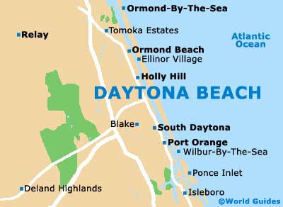
Daytona Beach is roughly divided into two main regions by the Halifax River lagoon, which is connected to the Intracoastal Waterway. Both Ormond Beach and Holly Hill lie to the north, while Port Orange and South Daytona are to be found to the south.
Interstate I-95 (North Tomoka Farms Road) runs parallel to the coastline, being roughly 4.5 miles / 7 km inland and connecting northern destinations such as Palm Coast, the Graham Swamp Conservation Area, Flagler Beach, the Bulow Creek State Park and Ormond by the Sea. Head in a southerly direction along the I-95 and you will reach Port Orange, Edgewater, the Turnbull Hammock Conservation Area, the Brevard County Game Refuge and Titusville.
Maps and Orientation of the City
Many holiday makers vacationing in Daytona Beach choose to rent a car for the duration of their stay. Maps can therefore be worthwhile and are worth picking up if you pay a visit to the centrally located Daytona Beach Area Convention and Visitors Bureau on East Orange Avenue, which is situated close to St. Mary's Episcopal Church and the Halifax Historical Museum, and just across the East Orange Avenue bridge from the Jackie Robinson Ballpark.
- Altamonte Springs - 48 miles / 77 km (one hour and 15 minutes, southwest)
- Astor - 38 miles / 61 km (one hour, west)
- Beverly Beach - 23 miles / 37 km (40 minutes, north)
- Bunnell - 23 miles / 37 km (40 minutes, northwest)
- De Leon Springs - 28 miles / 45 km (45 minutes, west)
- Deltona - 29 miles / 47 km (45 minutes, southwest)
- Edgewater - 18 miles / 29 km (30 minutes, south)
- Flagler Beach - 21 miles / 34 km (35 minutes, north)
- Jacksonville - 92 miles / 148 km (two hours and five minutes, north)
- Kissimmee - 78 miles / 126 km (one hour and 50 minutes, southwest)
- Merritt Island - 77 miles / 124 km (one hour and 50 minutes, south)
- New Smyrna Beach - 15 miles / 24 km (25 minutes, south)
- Orlando- 56 miles / 90 km (one hour and 25 minutes, southwest)
- Palm Coast - 32 miles / 51 km (50 minutes, north)
- Pierson - 36 miles / 58 km (55 minutes, west)
- Port Orange - 6 miles / 10 km (12 minutes, south)
- Sanford - 45 miles / 72 km (one hour and ten minutes, southwest)
- Titusville - 47 miles / 76 km (one hour and 15 minutes, south)
Map of the United States

Map of Florida

Map of Daytona Beach