Washington Maps and Orientation
(Washington, District of Columbia - DC, USA)
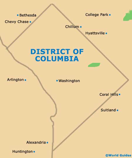
The American capital, Washington DC is edged by the Potomac River to the south, and by the neighboring state of
Maryland on its other boundaries. Bethesda, Silver Spring and Wheaton-Glenmont all lie to the north, while
Arlington is to the west and Alexandria to the south.
The historic layout of Washington was the result of two designers, Andrew Ellicott and Pierre L'Enfant. It was Ellicott who introduced the organized gridwork of streets, numbering north to south streets and giving letters to roads heading east to west, while L'Enfant introduced diagonal streets named after states, such as Florida Avenue, Maryland Avenue, New York Avenue, Pennsylvania Avenue and Rhode Island Avenue.
Washington DC maps often show how the city is roughly divided into four regions, with many of the principal sights residing within the Northwest Quadrant. Attractions here include the National Smithsonian Zoo and a number of museums based to the north of the National Mall.
Maps and Orientation of the City
The Northeast Quadrant is where you will find the neighborhoods of Brentwood, Brookland, Edgewood, Fort Lincoln, Fort Totten, Marshall Heights, Michigan Park, Riggs Park and Woodridge, as well as part of Capitol Hill. Washington's Southeast Quadrant is home to some of the more neglected neighborhoods, with crime levels here being the highest within the District of Columbia.
The Southwest Quadrant resides on the southern side of the National Mall, being the smallest quadrant of Washington DC and based around the Anacostia River. Of note, when most locals mention Southwest, they are referring to the area close to downtown Washington, near the Capitol building.
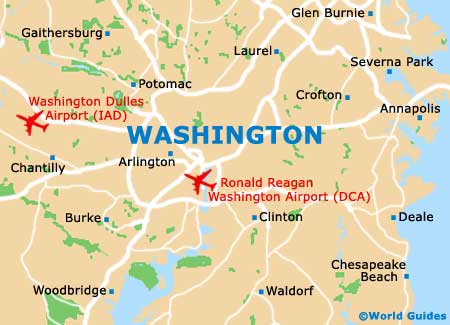
- Alexandria - 8 miles / 13 km (20 minutes, south)
- Annapolis - 33 miles / 53 km (55 minutes, east)
- Arlington - 5 miles / 8 km (12 minutes, west)
- Baltimore - 40 miles / 64 km (one hour and five minutes, northeast)
- Beltsville - 16 miles / 26 km (30 minutes, northeast)
- Bethesda - 8 miles / 13 km (20 minutes, northwest)
- Bladensburg - 8 miles / 13 km (20 minutes, northeast)
- Capitol Heights - 7 miles / 11 km (18 minutes, east)
- Chevy Chase - 8 miles / 13 km (20 minutes, north)
- Chillum - 7 miles / 11 km (18 minutes, north)
- Coral Hills - 8 miles / 13 km (20 minutes, southeast)
- Fort Washington - 18 miles / 29 km (30 minutes, south)
- Huntington - 11 miles / 18 km (25 minutes, southwest)
- Hyattsville - 9 miles / 14 km (20 minutes, northeast)
- McLean - 10 miles / 16 km (22 minutes, northwest)
- Oxon Hill Glassmanor - 10 miles / 16 km (22 minutes, southeast)
- Silver Spring - 8 miles / 13 km (20 minutes, north)
- Suitland - 9 miles / 14 km (20 minutes, southeast)
Map of the United States

Map of the District of Columbia D.C.
Map of Washington D.C.