Ocho Rios Maps and Orientation
(Ocho Rios, St. Ann, Middlesex, Jamaica)
Ocho Rios occupies a stretch of north Jamaican shoreline and is relatively remote where
Montego Bay and Kingston Bay are concerned. It is, however, less than two hours away from either place, although that is a fair amount of time for
Jamaica, as the island is quite small.
The town centre itself is only a kilometre or so across and consists of a just a few main streets that can be negotiated with ease when using maps. At large, the town stretches from Dunn's River Falls (west) to White River (east) and is roughly 6 km / 4 miles wide. Main Street (A3) connects these points and goes right through the town, with most of the big malls and hotels lining this route.
Maps and Orientation of the Town / Resort
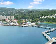
At the heart of Ocho Rios is a clock tower where Main Street and the equally busy DaCosta Drive meet. Turtle Bay is just to the north and features the resort town's main beach, Turtle Beach. The Turtle River cuts a swathe through the western part of town and has a park based around it. Cruise ships dock at two piers seemingly right in the town and both are within walking distance of beaches, hotels and malls.
Tourists can pick up pocket maps, as well as large fold-out maps, at kiosks in the town centre, and from the Jamaica Tourist Board office at the Ocean Villa Plaza. This is one of the main shopping centres and resides on Main Street.
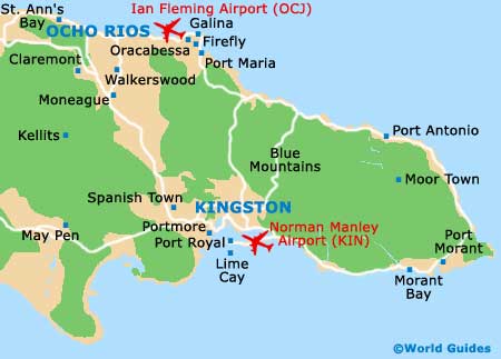
- Ian Fleming International Airport (formerly Boscobel Aerodrome) - 17 km / 11 miles (20 minutes, east)
- Discovery Bay - 34 km / 21 miles (35 minutes, west)
- Firefly - 29 km / 18 miles (30 minutes, east)
- Galina Point - 26 km / 16 miles (30 minutes, east)
- Green Grotto Caves - 31 km / 19 miles (30 minutes, west)
- Kingston - 88 km / 55 miles (one hour and 45 minutes, south-east)
- Moneague - 21 km / 13 miles (25 minutes, south)
- Montego Bay - 102 km / 64 miles (one hour and 35 minutes, west)
- Oracabessa - 21 km / 13 miles (25 minutes, east)
- Runaway Bay - 28 km / 17 miles (30 minutes, west)
- St. Ann's Bay - 11 km / 7 miles (15 minutes, west)
- St. Elizabeth - 133 km / 82 miles (two hours and 20 minutes, south-west)
Map of Jamaica

Map of Ocho Rios