Freeport Maps and Orientation
(Freeport, Grand Bahama, Bahamas)
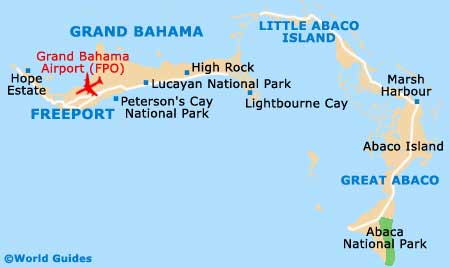
Freeport is located on the western end of Grand Bahama, just minutes from the international airport and a few kilometres from the beaches. This is the urban centre of the island, encompassing the areas of Freeport, the International Bazaar and Port Lucaya. Each of these three centres is just a few minutes from the other, although you will need a taxi to move between them. Once inside the individual areas, however, all three can easily be explored on foot.
Port Lucaya is virtually on the coast, woven into the maze of inland waterways that make up the south-west side of Grand Bahama. It is the newest area of development on the island, as well as the port for inbound cruise ships. You can find decent maps and tourist information at the Grand Bahama Tourism Board, with the main office being located on West Mall Drive at Poinciana Drive. Alternatively you can find abbreviated versions at the Grand Bahama International Airport, Port Lucaya Marketplace and the docks next to Lucayan Harbour. The smaller kiosks are open daily from 09:00 to 17:00.
Maps and Orientation of the City
It is fairly easy to navigate the flat streets of Freeport and Lucaya if you are used to driving on the left side of the road. Freeport is bisected by the island's largest roads, as it was originally planned to be the site of the biggest resorts on the island. Lucaya is sited just 4 km / 2.5 miles to the south, right on the southern waterfront. The East Sunrise Highway runs from Freeport through the International Bazaar and on to Lucaya. Good signage makes it easy to get around.
At the heart of Port Lucaya is the architectural wonder - Count Basie Square. Most of Lucaya's hotels are just a short walk to the east or west of the square, which is the entertainment hub of Port Lucaya. The rest of Grand Bahama is noticeably less glamorous. Industrial complexes spread out to the west of Freeport, followed by the grim docks of Freeport Harbour. Keep going west, though, and you will reach some lovely little Bahamian villages. The island's East End is even more isolated and very scenic. You can find the Lucayan National Park and the village of Free Town on this part of the island.
- East End - 72 km / 45 miles (three hours, east)
- Free Town - 19 km / 11 miles (30 minutes, east)
- International Bazaar - 2 km / 1 mile (five minutes, south)
- Lucayan National Park - 31 km / 19 miles (40 minutes, east)
- Palm Beach, Florida - 81 km / 50 miles (one hour, north-east)
- Port Lucaya - 4 km / 2.5 miles (five minutes, south)
- Rand Nature Centre - 5 km / 3 miles (five minutes, east)
- West End - 40 km / 25 miles (one hour, west)
Map of the Bahamas

Map of Freeport