Lloret de Mar Maps and Orientation
(Lloret de Mar, Catalonia, Spain)
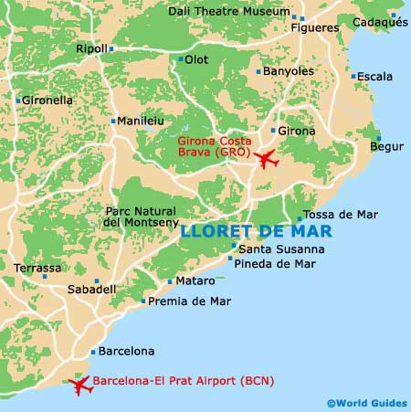
Lloret de Mar lies on the northern Mediterranean coast of Spain, between the sea and the Spanish Pyrenees. The Costa Brava (Wild Coast) is a region of rocky inlets, bays and long beaches with a backdrop of mountains containing towns and villages on their lower slopes.
To travel around the narrow mountain roads and visit tiny traditional villages, a good map is essential and can be obtained on arrival form your hotel's front desk or the tourist office. For a more detailed map of Lloret de Mar, downloading or ordering online is the best option.
Maps and Orientation of the Town
Navigating your way around Lloret de Mar is straightforward - the town is not so large and most of the places of interest, including the beaches, their tourist attractions and eateries, and the town centre, are within walking distance of each other. Maps showing the various in-town attractions can be picked up at the tourist office or at local hotels.
Lloret de Mar is sandwiched between the resorts of Blanes to the west and Tossa de Mar to the east. Roads in the coastal region are generally in good condition, but wind around the region's topography, increasing journey times between destinations.
- Barcelona - 76 km / 47 miles (one hour and ten minutes, south-west)
- Blanes - 7 km / 4 miles (15 minutes, south-west)
- Caldes de Malavella - 28 km / 17 miles (35 minutes, north)
- Escala - 82 km / 51 miles (one hour and 30 minutes, north / north-east)
- Figueres - 80 km / 50 miles (one hour and 15 minutes, north)
- Girona - 42 km / 26 miles (45 minutes, north)
- Mataro - 43 km / 27 miles (45 minutes, south-west)
- Palamos - 56 km / 35 miles (one hour, north)
- Rosamar - 25 km / 16 miles (35 minutes, north-east)
- Sant Feliu de Guixols - 32 km / 20 miles (40 minutes, north-east)
- Santa Cristina d'Aro - 38 km / 24 miles (45 minutes, north / north-east)
- Tossa de Mar - 11 km / 7 miles (20 minutes, east)
Map of Spain

Map of Lloret de Mar