Lodz Maps and Orientation
(Lodz, Western Mazovia, Poland)
As the third-biggest city in
Poland after the capital of
Warsaw and also
Krakow, it will hardly be a surprise to learn the Lodz is large, spreading and at times a little overwhelming. Lodz is located in the very heart of Poland and within Western Mazovia, boasting an overall population soon to exceed 800,000 residents, with the metropolitan area of Lodz currently topping 1.3 million people.
The Ulica Piotrkowska is the main artery in Lodz and runs in a north to south direction for almost 4 km / 2.5 miles. This long stretch is where you will find the majority of the main sights, shops, restaurants and hotels located, or extremely close by.
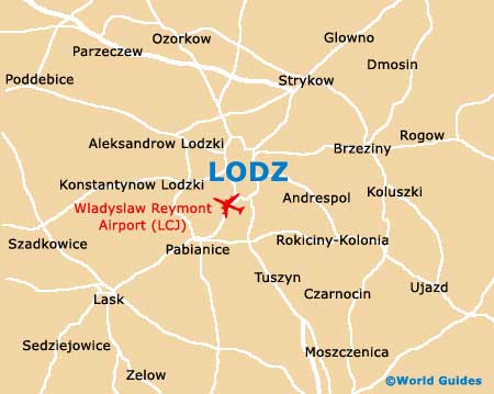
Maps and Orientation of the City
The northern side of the Ulica Piotrkowska is home to both the Lodz Fabryczna (main railway station) and the Dworzec Centralny PKS (bus station). Close by, a further railway station is located approximately 1.5 km / 1 mile to the west of the Ulica Piotrkowska and still near to Lodz city centre itself.
For maps of Lodz and this region of Poland, look no further than the larger bookshops along the Ulica Piotrkowska. Alternatively, visit the Lodz Cultural Information Centre (Centrum Informacji Kulturalnej) on the Ulica Zamenhofa, or the Tourist Information Centre (Centrum Informacji Turystycznej) on the Al Kosciuszki.
- Bydgoszcz - 256 km / 159 miles (three hours and 45 minutes, north-west)
- Czestochowa - 121 km / 75 miles (one hour and 50 minutes, south)
- Kielce - 147 km / 91 miles (two hours and 25 minutes, south-east)
- Konin - 130 km / 81 miles (two hours and 15 minutes, north-west)
- Krakow (Cracow) - 260 km / 162 miles (three hours and 50 minutes, south)
- Lowicz - 55 km / 34 miles (one hour, north-east)
- Ostrów Wielkopolski - 133 km / 83 miles (two hours and 15 minutes, west)
- Pabianice - 16 km / 10 miles (20 minutes, south)
- Piotrków Trybunalski - 50 km / 31 miles (55 minutes, south)
- Plock - 117 km / 73 miles (two hours, north)
- Poznan - 218 km / 135 miles (three hours and 40 minutes, north-west)
- Radom - 137 km / 85 miles (two hours and 15 minutes, south-east)
- Torun - 163 km / 101 miles (two hours and 50 minutes, north)
- Warsaw (Warszawa) - 137 km / 85 miles (two hours and 15 minutes, north-east)
- Wroclaw - 211 km / 131 miles (three hours and 40 minutes, south-west)
- Zabrze - 190 km / 118 miles (three hours, south)
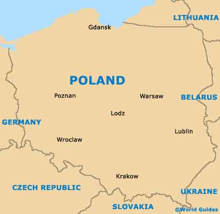
Map of Poland
Map of Lodz