Szeged Maps and Orientation
(Szeged, Csongrad, Hungary)
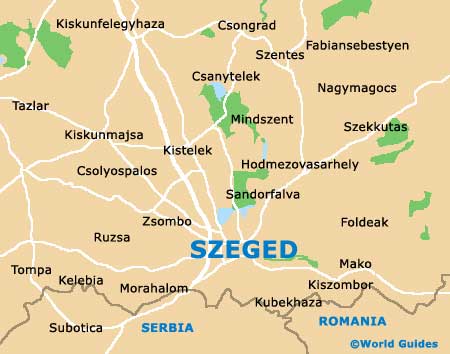
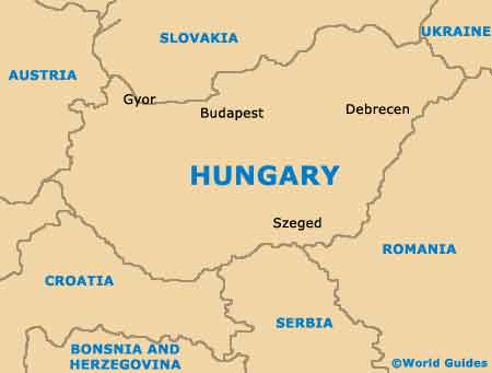
Hungary's fourth-biggest city of Szeged is located on the far south-eastern side of the country, within the Csongrad county and on the Southern Plain. Currently, Szeged has a population of roughly 170,000 residents and has grown up around the extremely wide River Tisza, which is joined by the River Maros.
The many public squares and ring roads in the Szeged area makes getting around this city quite confusing for some. However, throughout Szeged are plenty of clear signposts, often written in several different languages.
Maps and Orientation of the City
The main railway station in Szeged lies on the southerly side of the city centre and is known in Hungarian as the Indóház Tér, while on the western side of the city is the bus station (Marstér). Close by is the traffic-free Miksázth Kálmán Utca, a prominent thoroughfare in this part of Szeged which has been completely pedestrianised.
Maps of Szeged are always desirable and will certainly make finding your way around easier. There is a map shop located along the Attila Utca, while outlets of Tourinform Szeged can be found on the Dugonics Tér and also the Széchenyi Tér.
- Baja - 101 km / 63 miles (one hour and 40 minutes, west)
- Békéscsaba - 95 km / 59 miles (one hour and 40 minutes, north-east)
- Belgrade (Serbia) - 330 km / 205 miles (five hours and 40 minutes, south)
- Budapest - 170 km / 105 miles (two hours and 15 minutes, north-west)
- Csongrad - 36 km / 22 miles (50 minutes, north)
- Kalocsa - 160 km / 99 miles (two hours and 40 minutes, north-west)
- Kecskemét - 87 km / 54 miles (one hour and 20 minutes, north-west)
- Kiskunhalas - 58 km / 36 miles (one hour and ten minutes, north-west)
- Pécs - 180 km / 112 miles (two hours and 55 minutes, west)
- Szarvas - 88 km / 55 miles (one hour and 20 minutes, north)
- Székesfehérvár - 227 km / 141 miles (three hours and 20 minutes, north-west)
- Szentes - 53 km / 33 miles (one hour and five minutes, north)
- Szolnok - 160 km / 99 miles (two hours and 40 minutes, north)
- Timisoara (Romania) - 165 km / 103 miles (two hours and 45 minutes, south-east)
Map of Hungary
Map of Szeged