Nuremberg Maps and Orientation
(Nuremberg, Bavaria, Germany)
Standing within the state of Bavaria, Nuremberg lies in southern Germany and is known for its reconstructed city walls, which surround the historic Altstadt district. Nuremberg has grown around the Pegnitz River and is also home to the acclaimed Rhine-Main-Danube Canal, a particularly important Bavarian waterway that links both the Danube River and the Main River.
Within Nuremberg's Altstadt old town area you will find many of the city's best tourist attractions, most of which are within walking distance of each other. The Hauptbahnhof train station is sited on the outskirts of the Altstadt area and to the south-east. This spot is connected to the very heart of Nuremberg by the Königstrasse, an important local thoroughfare next to the winding Pegnitz River.
Maps and Orientation of the City
A great way to explore the Altstadt area of Nuremberg is to join one of the regular walking tours. The tours begin at the Hauptmarkt (market square) and then head northwards towards the castle, passing many outstanding, historical sights en route.
Nuremberg lies to the north of nearby Munich and is also close to a number of other prominent German cities and towns. Many excellent sightseeing opportunities are to be found within the following nearby destinations, most of which are extremely close to Nuremberg and highly suitable for day trips.
- Brunn - 18 km / 11 miles (20 minutes, east)
- Erlangen - 21 km / 13 miles (25 minutes, north)
- Feucht - 19 km / 12 miles (25 minutes, south-east)
- Frankfurt Am Main - 217 km / 135 miles (three hours, north-west)
- Fürth - 8 km / 5 miles (12 minutes, west)
- Heroldsberg - 11 km / 7 miles (15 minutes, north-east)
- Herzogenaurach - 24 km / 15 miles (25 minutes, north-west)
- Kraftshof - 8 km / 5 miles (12 minutes, north)
- Munich - 168 km / 105 miles (two hours and 20 minutes, south)
- Oberasbach - 14 km / 9 miles (20 minutes, west)
- Stuttgart - 211 km / 131 miles (two hours and 40 minutes, south-west)
- Wendelstein - 18 km / 11 miles (20 minutes, south)
- Zirndorf - 16 km / 10 miles (20 minutes, west)
Map of Germany

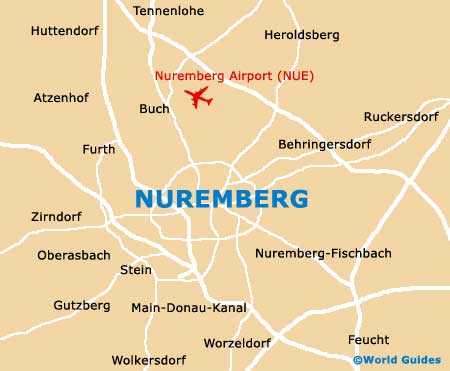
Map of Nuremberg