Stuttgart Maps and Orientation
(Stuttgart, Baden-Wurttemberg, Germany)
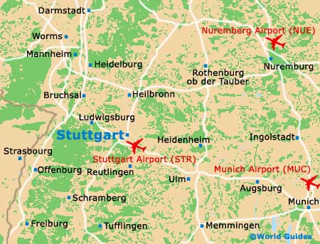
Stuttgart spreads out across several valleys and vineyard-covered hills, with the River Neckar running nearby. The Black Forest is an hour's drive away, as is the Swabian Jura, and autoroutes make travelling by road both trouble-free and fast. The A8 and A81 state highways cross close to the city centre, providing easy access to and from the outer urban areas.
The city of Stuttgart, the sixth-largest in Germany, lies at the centre of hundreds of villages, small towns and suburban areas in the far south of Germany, close to the borders with
France and
Switzerland.
Frankfurt is located to the north and
Munich to the south-east.
Maps and Orientation of the City
For local reference or when planning sightseeing trips across the region, maps are easily available either online, at the tourist office or from your hotel's front desk. If you are hiring a car, your supplier should always include a map.
- Baden-Baden - 113 km / 70 miles (one hour and 20 minutes, west)
- Bad Rappenau - 75 km / 47 miles (one hour, north)
- Essingen - 73 km / 45 miles (one hour, west)
- Heidelberg - 121 km / 75 miles (one hour and 20 minutes, north-west)
- Karlsruhe - 80 km / 50 miles (one hour and ten minutes, north-west)
- Ludwigsburg - 16 km / 10 miles (15 minutes, north)
- Mannheim - 132 km / 82 miles (one hour and 25 minutes, north-north-west)
- Memmingen - 157 km / 98 miles (one hour and 35 minutes, south-east)
- Naturpark Schonbuch - 29 km / 18 miles (30 minutes, south-west)
- Reutlingen - 39 km / 24 miles (35 minutes, south)
- Rottemburg am Neckar - 38 km / 24 miles (35 minutes, south-west)
- Schwabisch Hall - 95 km / 59 miles (one hour and 15 minutes - north-east)
- Strasbourg - 167 km / 104 miles (one hour and 50 minutes, west)
- Tubingen - 40 km / 25 miles (35 minutes, south)
- Wurzburg - 147 km / 92 miles (one hour and 35 minutes, north-east)
Map of Germany

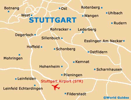
Map of Stuttgart