Eastbourne Maps and Orientation
(Eastbourne, East Sussex, England, UK)
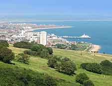
Located on the coastline of south-east
England and within the county of East Sussex, the town of Eastbourne stands on the easterly side of the South Downs. Eastbourne enjoys a relatively sheltered situation and is to be found next to the Beachy Head cliffs.
Eastbourne is first and foremost a seaside resort, although the town does also include a series of sizeable residential areas and trading estates. Apart from the beachfront and the town centre itself, the most noteworthy neighbourhoods and suburbs include Bridgemere, Downside, Hampden Park, Langney, Ocklynge, Rodmill and also Sovereign Harbour.
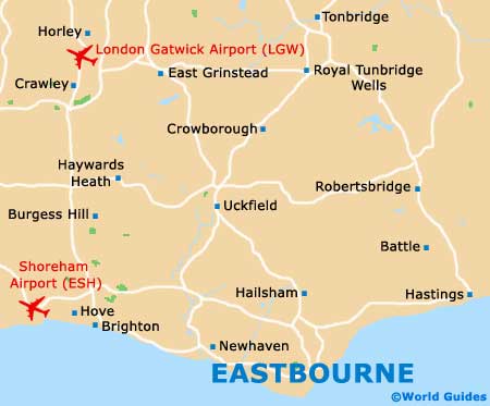
Maps and Orientation of the Town
Central Eastbourne is simple to find your way around and the beachfront is just a matter of minutes away from the main shops. For maps of the town and area, the Eastbourne tourist outlet resides on Cornfield Road, next to the pedestrian precinct, the Arndale Centre and the Labyrinth.
A major road runs parallel to the coastline, comprising King Edward's Parade, Grand Parade, Marine Parade and Royal Parade.
- Bognor Regis - 82 km / 51 miles (one hour and 25 minutes, west)
- Brighton - 35 km / 22 miles (45 minutes, west)
- Chichester - 86 km / 54 miles (one hour and 30 minutes, west)
- Crawley - 67 km / 42 miles (one hour and five minutes, north-west
- Dover - 110 km / 69 miles (one hour and 50 minutes, north-east)
- Folkestone - 90 km / 56 miles (one hour and 40 minutes, north-east)
- Guildford - 126 km / 79 miles (two hours, north-west)
- Hailsham - 16 km / 10 miles (22 minutes, north)
- Hastings - 27 km / 17 miles (35 minutes, east)
- Heathfield - 27 km / 17 miles (35 minutes, north)
- Lewes - 26 km / 16 miles (30 minutes, north-west)
- London - 117 km / 73 miles (one hour and 55 minutes, north)
- Maidstone - 70 km / 44 miles (one hour and 20 minutes, north-east)
- Newhaven - 21 km / 13 miles (25 minutes, west)
- Peacehaven - 26 km / 16 miles (35 minutes, west)
- Portsmouth - 115 km / 72 miles (one hour and 50 minutes, west)
- Royal Tunbridge Wells - 51 km / 32 miles (55 minutes, north)
- Seaford - 16 km / 10 miles (22 minutes, west)
- Shoreham-by-Sea - 50 km / 31 miles (50 minutes, west)
- Southampton - 136 km / 85 miles (two hours and ten minutes, west)
- Woking - 123 km / 77 miles (two hours, north-west)
- Woodingdean - 37 km / 23 miles (40 minutes, west)
- Worthing - 56 km / 35 miles (one hour, west)
Map of the United Kingdom

Map of Sussex
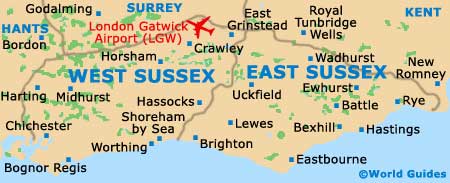
Map of Eastbourne