Shah Alam Maps and Orientation
(Shah Alam, Selangor, Malaysia)
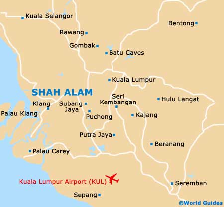
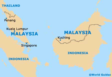
Shah Alam is a sizeable city to the south-west of Kuala Lumpur, within a conurbation that also includes Klang, Petaling Jaya and Subang Jaya. It resides near the west coast of Peninsula Malaysia, roughly in the centre of the Selangor State, and is located some 27 km / 17 miles south-west of the capital.
On
Malaysia maps, Shah Alam is just above the Kelang River, with Klang a few kilometres to the west, Petaling Jaya a few kilometres to the east, and Subang Jaya further south.
Maps and Orientation of the City
The city is divided up into sections (or seksyen) and there are 56 altogether. The centre of Shah Alam is focused roughly around Section 14 and this is where the Lake Gardens reside, along with many of the best hotels and shopping malls.
Shah Alam is laid out in a similar fashion as nearby Subang Jaya and Petaling Jaya, and roads and streets have Roman and Jawi script signage. City maps can be ordered online before you travel, or alternatively obtained from your hotel or the local tourist information office.
- Cameron Highlands - 206 km / 128 miles (two hours and 30 minutes, north)
- Ipoh - 208 km / 129 miles (two hours and 30 minutes, north)
- Johor Bahru - 342 km / 212 miles (four hours, south-east)
- Klang - 16 km / 10 miles (20 minutes, south-west)
- Kuala Lumpur Airport (KLIA) - 50 km / 31 miles (45 minutes, south-east)
- Kuala Lumpur - 27 km / 25 miles (30 minutes, north-east)
- Kuala Selangor - 53 km / 50 miles (one hour, north-west)
- Malacca - 153 km / 95 miles (two hours, south-east)
- Malacca Klang - 28 km / 17 miles (30 minutes, south-west)
- Petaling Jaya - 13 km / 8 miles (15 minutes, north-east)
- Putrajaya - 40 km / 25 miles (45 minutes, south-east)
- Subang Jaya - 15 km / 9 miles (20 minutes, south-east)
Map of Malaysia
Map of Shah Alam