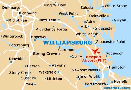
Williamsburg Maps and Orientation
(Williamsburg, Virginia - VA, USA)
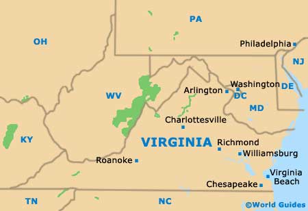
Located on the eastern side of Virginia and roughly 55 miles / 89 km to the southeast of
Richmond, Williamsburg functions as an 'independent city', meaning that it is not actually part of any county as such. However, its boundaries are edged by both York County and James City County.
Williamsburg belongs to the Hampton Roads Metropolitan Area, along with both
Virginia Beach and Norfolk. Many important parks and reserves are to be found close to Williamsburg, such as the Waller Mill Park and the York River State Park to the north, and the Chickahominy Wildlife Management Area to the far west. Cobham Bay and the Hog Island State Waterfowl Refuge lie to the south, while the expansive military reservation of Camp Peary is to the north.
Jamestown, Williamsburg and Yorktown combine to make up the Historic Triangle area, on the Virginia Peninsula. The living history museum known as the Jamestown Festival Park is a major highlight in this area, boasting a number of important replica ships from yesteryear.
Maps and Orientation of the City
For tourists, much of the interest resides in Colonial Williamsburg, an especially historic part of the city known for its period buildings from the 17th and 18th centuries.
Colonial Williamsburg covers a huge area of more than 170 acres / 69 hectares and entrance to this historic district is completely free of charge, although there may be an admission charge for entry into some of the buildings and gardens. Informative guided tours are available, along with maps should you prefer to find your way around at your own pace.
- Chickahominy Riverfront Park - 11 miles / 18 km (20 minutes, west)
- Colonial National Historical Park - 14 miles / 23 km (25 minutes, east)
- Denbigh - 18 miles / 29 km (35 minutes, southeast)
- Fort Eustis - 16 miles / 26 km (30 minutes, southeast)
- Gloucester Point - 18 miles / 29 km (35 minutes, east)
- Greenwood - 13 miles / 21 km (25 minutes, southeast)
- Hampton - 29 miles / 47 km (45 minutes, southeast)
- Newport News - 22 miles / 35 km (40 minutes, southeast)
- Providence Forge - 27 miles / 43 km (45 minutes, northwest)
- Reservoir - 16 miles / 26 km (30 minutes, southeast)
- Richneck - 16 miles / 26 km (30 minutes, southeast)
- Toano - 12 miles / 19 km (25 minutes, northwest)
- Waller Mill Park - 5 miles / 8 km (12 minutes, north)
- Windsor - 17 miles / 27 km (30 minutes, southeast)
- York River State Park - 13 miles / 21 km (25 minutes, north)
- Yorktown - 13 miles / 21 km (25 minutes, east)
Map of the United States

Map of Virginia
Map of Williamsburg